U-123 - 5th War Patrol
Translation by Jerry Mason with help from Andi Forster
Departed |
Date |
Arrived |
Date |
Days at Sea |
Lorient |
15 Jun 1941 |
Lorient |
23 August 1941 |
70 |
| Click the icon to download a KMZ file displaying the U-boat track, significant events and locations for this patrol. You must have Google Earth loaded on your computer to view this file. Download Google Earth here |
Ships Hit |
||||||
Date |
KTB Time |
Position |
Ship |
Tons |
Nationality |
Convoy |
20 Jun
41 |
20.10 |
34°15'N,
11°34'W |
GANDA |
4,333 |
Portuguese |
|
27 Jun
41 |
23.57 |
25°45'N,
23°57'W |
P.L.M.
22 |
5,646 |
British |
SL 78 |
27 Jun
41 |
23.58 |
25°45'N,
23°57'W |
OBERON |
1,996 |
Netherlands |
SL 78 |
29 Jun
41 |
19.36 |
29°15'N,
27°58'W |
RIO AZUL |
4,088 |
British |
SL 78 |
4 Jul
41 |
03.55 |
25°51'N,
28°33'W |
AUDITOR |
5,444 |
British |
OB 337 |
Total = 21,507 |
||||||
| Note: The positions in the table above and in the Google Earth patrol summary are derived from the KTB and in many cases do not match those recorded in authoritative references such as Jürgen Rohwer, Axis Submarine Successes of World War Two or the Uboat.net website. The goal here is to present the picture relative to the U-boat and not the absolute position that the ship was attacked or sank. | ||||||
| This KTB uses the depth notation "depth T = xx meters" Under this scheme, the actual depth was twice the depth given after T = so for example, if the KTB entry read "depth T = 50 meters, the actual depth was 100 meters. This was intended to hide the actual depth for security purposes. This notation was used from about January 1940 to December 1941. In these KTBs, depths written without using "T =", for example "dived to depth 35 meters" were not so disguised. |
| |
|||||
| K r i e g s t a g e b u c h | |||||
| ====================== | |||||
| " U 123 " | |||||
| ________ | |||||
| Kommandant: Kaptlnt. H a r d e g e n . | |||||
| Beginning: 12 May 1941. | |||||
| Ending: 23 August 1941. | |||||

|
|||||
 |
|||||
| |
|||||
| © U-boat Archive 2025 - all rights reserved | |||||
 |
Click the flag to view the above page from the original German KTB |
- 2 - |
|||||
| 12.05.41 | Lorient |
Shipyard period. | |||
| 13.05.41 | " | Muster by B.d.U. | |||
| 14.05.41 | " | Shipyard period, dry docked, transfer of the boat from Kaptlt. Möhle to I.W.O. Obltn. z.See Müller. | |||
| 19.05.41 | " | Transfer of the boat from Obltn. z.See Müller to Kaptlt. Hardegen. | |||
| 27.05.41 | " | Undocked, shipyard period up to 2 June. | |||
| 03.06.41 | " | Propeller damaged during dockyard testing. | |||
| 04.06.41 | " | Dry docked, port propeller replaced. | |||
| 05.06.41 | " | Undocked, torpedo loading, fuel oil loading, ammunition loading, degaussing, calibration of direction finder, trimming, test dive. | |||
| 06.06.41 | " | Fitting out for southern war patrol, Trim test. | |||
| 07.06.41 | " | Took over the boat. Provisions loading. | |||
| _ . _ . _ . _ . _ . _ | |||||
| During this shipyard downtime sponsorship of U-123 was assumed by II Battalion / 358 in Le Pouldu. The solemn assumption took place on 29.05.41 in Le Pouldu through the Kommandant by the Battalion Commander, Army Major Kammerer. On 31.05.41 (the boat is a year in service) and on 01.06.41 a large delegation of the crew were guests of the battalion. | |||||
|
|
|||||
| 08.06.41 | Lorient | ||||
| 18.41 | Put to sea on 5th war patrol with "U-201". | ||||
| 19.05 | Taken under escort. Sea trial with M.A.N. personnel. 4 men handed over to the escort. | ||||
| 22.45 | Released escort, test dive. | ||||
| 23.13 | Surfaced. Proceeded to Point Caesar at 2 x GF. | ||||
|
|
|||||
|
Sun and Moon Data 08.06.41 |
- 3 - |
|||||
| 09.06.41 | Bay of Biscay | ||||
| 04.00 | BF 6484 lower-left | Course 233°. | |||
| SEbyS, rain, Sea 2, Vis. 4 nm | |||||
| 08.00 | BF 5861 lower-right | Course 233°, both HF. | |||
| SSW 3, 3/10, Sea 2-3, Vis. 8 nm, half moon | |||||
| 12.00 | BF 5882 upper-left | Proceeding on one engine at HF. Intend to head for the NW corner of Spain, then contine to the south. | |||
| SbyW 4-5, 9/10, Sea 3-4, Vis. 15 nm | |||||
| Day's run: 144 nm |
|||||
| 16.00 | BF 5876 | ||||
| WSW 3-4, 8/10, Sea 3, Vis. 15 nm | |||||
| 20.00 | BF 8311 | ||||
| NWbyW 4, 0/10, Sea 4, Vis. 15 nm | |||||
| 24.00 | BF 8237 | ||||
| NNW 2, 4/10, Sea 3-4, Vis. 10 nm, moonshine | |||||
|
|
|||||
| 10.06.41 | |||||
| 04.00 | BF 8253 lower-left corner | ||||
| WNW 3-4, 7/10, Sea 3, Vis. 10 nm | |||||
| 08.00 | BF 8196 | ||||
| As above | |||||
| 12.00 | BF 8197 lower-left corner | Day's run: 118 nm |
|||
| NWbyW 2-3, 7/10, Sea 3, Vis. 15 nm | total: 262
nm |
||||
| 16.00 | BF 8423 | Since yesterday the hydraulic oil system is out of service. Approximately 250 liters of oil leaked from two flanges in the control room bilge. After replenishing the oil the system did not work. Tried with onboard means to repair the damage. | |||
| NWbyW 3-4, 3/10, Sea 3, Vis. 15 nm | |||||
| 20.00 | BF 8419 | ||||
| NWbyW 2-3, 3/10, Sea 2, Vis. 10 nm | |||||
| 24.00 | BF 8444 | ||||
| WbyN 1, 6/10, Sea 1-2, Vis. 3 nm, weak moon | |||||
|
|
|||||
| 11.06.41 | |||||
| 04.00 | BF 7691 | ||||
| SWbyW 1-2, 6/10, Sea 1-2, Vis. 3 nm, light rain | |||||
| 06.30 | |||||
| 07.43 | BF 7912 | ||||
| 09.30 | Passed 9°W, short signal sent: | ||||
| "Position square BF 78." Was acknowledged. | |||||
| 12.00 | BF 7861 | Day's run: 128 nm | |||
| SSW 4, 10/10, rain, Sea 3, Vis. 1.5 nm | total: 390 nm | ||||
| of that:
6 nm |
|||||
|
Sun and Moon Data 09.06.41 |
| Sun and Moon Data 10.06.41 |
- 4 - |
|||||
| continued: | |||||
| 11.06.41 | |||||
| In spite of 48 hours of continuous work we do not succeed in getting the hydraulic oil installation in operation. As a result, both periscopes are out of service, I decide to return to repair the damage in Lorient. It is not responsible to continue the patrol. It is a disadvantage that both periscopes rely on the same installation. As a result both are out of service. It would be useful, if for example, the air search periscope could be extended and retracted purely electrically, so that there is a real reserve periscope, or to alter the installation so that it can be driven with normal lubricating oil. | |||||
| 16.00 | BF 7854 | On course 54°, both diesels GF. Radio message to B.d.U. concerning return and description of the malfunction. | |||
| SSW 2-3, 10/10, Sea 2, Vis. 2-3 nm | |||||
| 19.30 | Short signal: "Positioned 24 hours off return harbor." Was acknowledged. | ||||
| 20.00 | BF 7676 | ||||
| SSW 2-3, 10/10, Sea 2, Vis. 1-2 nm | |||||
| 24.00 | BF 8418 | ||||
| SW 2, 10/10, Sea 2, Vis. 1 nm | |||||
|
|
|||||
| 12.06.41 | Bay of Biscay | ||||
| 04.00 | BF 8245 | ||||
| SW 2, 9/10, Sea 2, Vis. 1 nm | |||||
| 08.00 | BF 5875 | ||||
| As above | |||||
| 09.00 | 2 fishing trawlers abeam to starboard. 2 nm distant. | ||||
| 12.00 | BF 5834 | Day's run: 322 nm | |||
| WNW 3, 9/10, Sea 2-3, Vis. 7 nm | total: 722 nm | ||||
| of that:
6 nm |
|||||
| 14.00 | Several fishing trawlers and fishing smacks in sight to port and starboard, about 12°. By short signal requested radio beacon for 15.30 hours. Ran in the ordered route. | ||||
| 19.15 | Positioned at Point Luzie II. No convoy in sight. Went to Point V. Taken under escort there. | ||||
| 20.45 | Lorient | Made fast to ISÈRE alongside "U-66". | |||
| Experience: The hydraulic oil installation is filled with 460 liters of special oil, with 50 liters in reserve. After the loss of 250 liters we had to refill with 200 liters of lubricating oil | |||||
|
Sun and Moon Data 11.06.41 |
| Sun and Moon Data 12.06.41 |
- 5 - |
|||||
| continued: | |||||
| 12.06.41 | |||||
| which is more viscous. The whole installation including the pumps was removed, after it was determined that they would not operate. The cause could not be determined. An assertion from the shipyard, that it had been a rag in the hydraulic oil reservoir cannot be agreed with, because we only removed the installation, when we learned, that they would not operate with lubricating oil. The rag could only have come from the shipyard. In addition, after assembly all piping was blown with oil and compressed air. They were clear. However, the pumps did not operate. Now, after replenishment with special oil the installation runs perfectly again, so that the fault was only with the oil. Why both flanges could loosen, must still be checked. This was the main cause of the malfunction. Additionally, I refer to my statement of 11 June. | |||||
|
|
|||||
| 13.06.41 | Lorient | Repairs to the hydraulic oil installation, loading of new fresh provisions. Fuel oil replenishment. It turns out, that main ballast tank 8 vents. Some stuffing boxes are leaking, so that the boat must dry dock again briefly. | |||
|
|
|||||
| 14.06.41 | Lorient | ||||
| On the basis of "U-105" experience 70 shots of incendiary ammunition are exchanged for explosive ammunition. | |||||
| Torpedo and armament servicing. | |||||
| 20.00 | Entered dry dock | ||||
|
|
|||||
| 15.06.41 | Lorient | ||||
| 08.00 | WNW 3, 9/10, Sea 2, Vis. 7 nm | Undocked from Dock III, to depart on war patrol. | |||
| 08.35 | Taken under escort. | ||||
| 10.35 | Released from escort at Point Luzie II, running at 2 x GF. | ||||
| 11.50 | |||||
| 12.00 | Bay of Biscay | Day's run inclusive of | |||
| BF 6177 | Remaining distance from 12 June: 137 nm | ||||
| total: 859 nm | |||||
|
of that: 6.5 nm |
|||||
| 16.00 | BF 5532 | ||||
| 17.20 | WbyN 1, 10/10, Sea 1, Vis. fluctuates 1-3 nm | Surfaced at point Bogen, course 223° both engines GF. | |||
|
Sun and Moon Data 15.06.41 |
- 6 - |
|||||
| continued: | |||||
| 15.06.41 | |||||
| 20.00 | BF 5557 | ||||
| WNW 2, 10/10, Sea 1-2, heavy haze, Vis. sometimes under 1 nm | |||||
| 24.00 | BF 5739 | Went to both engines HF. | |||
| Wind calm, fog, Sea 0, light swell, Vis. 150-300 meters | |||||
|
|
|||||
| 16.06.41 | |||||
| 04.00 | BF 5759 | ||||
| E 1, 10/10. Sea 1, Vis. 500 meters, fog | |||||
| 08.00 | BF 8211 | ||||
| ENE 2, 10/10, Sea 1, Vis. 2-3 nm, heavy haze | |||||
| 12.00 | BF 8158 | Day's run: 199.5 nm | |||
| EbyS 3, 3/10, Sea 2, Vis. 3-5 nm | total: 1058 nm | ||||
| of that:
28.5 nm |
|||||
| 16.00 | BF 7634 | ||||
| EbyS 3-4, 1/10, Sea 3, Vis. 20 nm | |||||
| 19.20 | Ahead a fishing trawler on course 260°, avoided. Shortly thereafter a second behind it. | ||||
| 19.38 | On old course 220°. | ||||
| 20.00 | BF 7649 | ||||
| EbyS 4-5, 1/10, Sea 4, Vis. 15 nm | |||||
| 24.00 | BF 7835 | ||||
| NEbyE 1, 0/10, Sea 0-1, Vis. 15 nm | |||||
|
|
|||||
| 17.06.41 | |||||
| 04.00 | BF 7873 | Passing report 9°W sent by short signal: "BF 78". On course 180°. | |||
| NEbyE 1, 0/10, Sea 0-1, Vis. 15 nm, moonshine | |||||
| 08.00 | CG 2219 | ||||
| SE 0-1, 1/10, Sea 0, Vis. 15 nm | |||||
| 09.18 | West Coast of Spain | ||||
| 09.29 | |||||
| 12.00 | CG 2273 | Day's run: 225.5 nm | |||
| NbyE 1, 2/10, Sea 1, Vis. 10 nm | total: 1283 nm | ||||
| of that:
29 nm |
|||||
| Course 140°. | |||||
| 16.00 | CG 2526 | ||||
| NE 1, 1/10, Sea 0, Vis. 15 nm | |||||
| 16.11 | 1 steamer bearing 320°T, course 10°, target angle 80°, maneuvered ahead at the limit of visibility. | ||||
| 18.13 | Wind calm, sea flat as glass | Dived to attack |
|||
| 20.00 | CG 2268 | ||||
| 21.04 | |||||
|
Sun and Moon Data 15.06.41 |
| Sun and Moon Data 16.06.41 | |
| Sun and Moon Data 17.06.41 |
- 7 - |
|||||
| continued: | |||||
| 17.06.41 | |||||
| On Sunday evening a 3/4 of a flange from the diesel air-compressor was broken in 3 pieces. A new flange was cut with the autogenous welding gear from 18 mm steel plate and set behind the fragment with bolts. Clamps were electrically welded over the entire assembly. Today after 2 days the compressor is again conditionally operable for 180 kg. The work was well thought out by the engine personnel. | |||||
| 24.00 | CG 2297 | ||||
| E 1, 3/10, Sea 0-1, Vis. 8-10 nm | |||||
|
|
|||||
| 18.06.41 | |||||
| 00.10 | 2 lighted steamers sighted to port. No attack. | ||||
| 04.00 | CG 2556 | ||||
| SE 1, 1/10, Sea 0-1, Vis. 3-4 nm, moonshine | |||||
| 08.00 | CG 2822 | ||||
| SSE 0-1, fog, Sea 0-1, Vis. 300 meters - 1 nm | |||||
| 12.00 | CG 2855 | Day's run: 162 nm | |||
| Wind calm, fog, Sea 0, Vis. 300 meters - 1 nm | total: 1445 nm | ||||
| of that:
38 nm |
|||||
| 16.00 | CG 5521 | ||||
| N 0-1, 2/10, Sea 0, Vis. 8 nm | |||||
| 20.00 | CG 5249 | ||||
| NbyE 1, 1/10, Sea 0-1, Vis. 20 nm | |||||
| 24.00 | CG 5515 | ||||
| ENE 1, 7/10, Sea 1, Vis. 5 nm | |||||
|
|
|||||
| 19.06.41 | |||||
| 04.00 | CG 5499 | Came to course 226°. | |||
| ENE 1, 2/10, Sea 1, Vis. 5 nm | |||||
| 08.00 | CG 5755 | ||||
| SEbyS 2, 6/10, Sea 2, Vis. 15 nm | |||||
| 08.49 | Steamer in sight ahead to port. Bow right. Emerged quickly. Moved off at high speed and maneuvered ahead. Came quickly forward. Steamer runs at 8 knots. | ||||
| 09.14 | Crash dive. A large aircraft is with the steamer. | ||||
| 09.32 | Surfaced. Position of the steamer is still favorable. Target angle 20°, ran to meet across his course and dived at target angle 0°. Initiated stern attack out of the sun. Realize shortly before shooting: Spanish | ||||
|
Sun and Moon Data 17.06.41 |
| Sun and Moon Data 18.06.41 | |
| Sun and Moon Data 19.06.41 |
- 8 - |
|||||
| continued: | |||||
| 19.06.41 | |||||
| "MAR-TIRRENO", 3000 GRT, range = 480 meters. Again no! Steamer had large deck cargo, looked like cork. Ran off submerged. The aircraft might have been a "Condor". | |||||
| 12.03 | CG 5751 | Surfaced. | |||
| SEbyS 2, 6/10, Sea 2, Vis. 15 nm | Day's run: 189 nm | ||||
| total: 1634 nm | |||||
| of that:
46 nm |
|||||
| 12.55 | Incoming Radio Message: U-123. At 08.00 hours crew of an abandoned steamer in square CG 8294. | ||||
| I proceed at both engines GF on course 135°. Am 110 nm from the square. | |||||
| 13.22 | Incoming Radio Message: To U-123, English convoy was located 18 June at 17.00 hours 5 nm southwest of Cadiz, course northwest. | ||||
| I believe it is improbable that it will turn to the north at Saint Vincent, but believe it will go further to the west. I plot its advance at 8 knots. Then at about 17.00 hours I would have to be in position. | |||||
| 16.00 | CG 8133 | ||||
| SEbyS 2-3, 4/10, Sea 2, Vis. 15 nm | |||||
| 17.00 | According to the interception plot I must be positioned at the convoy. In spite of good visibility nothing is seen. Dived to listen, depth T = 20 meters. [actual depth 40 meters] Nothing heard. | ||||
| 17.24 | West Coast of Spain | Surfaced, course to the square of the reported steamer 8294. If the convoy runs slower, we must also still meet him on this course. Continuing to operate on him appears useless, because the information is too inaccurate and 24 hours old. | |||
| 20.00 | CG 8283 | ||||
| SbyE 7/10, Sea 2-3, Vis. 8 nm | |||||
| 20.50 | Positioned in square CG 8294. Nothing is seen of the steamer. Because I suppose that it was towed into a harbor (Lagos), I pursue on course 90° to Cape St. Vincent. | ||||
| 22.00 | Because of the approaching darkness on course 180°, course to Madeira 242°. One engine HF. Another search for the independent steamer in the darkness appears useless. I have bypassed the convoy. The information was too inaccurate, so that a meeting was a matter of luck. | ||||
| 24.00 | CG 8531 | ||||
| S 2, 8/10, Sea 1-2, Vis. 5 | |||||
|
|
|||||
|
Sun and Moon Data 19.06.41 |
- 9 - |
|||||
| 20.06.41 | |||||
| 04.00 | CG 8519 | ||||
| S 2, 9/10, Sea 1, Vis. 5 nm | |||||
| 08.00 | CG 8468 | ||||
| NW 2, 3/10, Sea 1, Vis. 15 nm | |||||
| 12.00 | CG 8489 | Day's run: 238 nm | |||
| total: 1872 nm | |||||
| of that: 50 nm Submerged. | |||||
| 16.00 | CG 8784 | ||||
| WbyS 2, 3/10, Sea 1-2, Vis. 15 nm | |||||
| 20.00 | DJ 1169 | ||||
| 24.00 | DJ 1169 | ||||
| SbyW, 8/10, Sea 1-2, Vis. 5 nm | |||||
|
|
|||||
| 21.06.41 | |||||
| 04.00 | DJ 1181 | ||||
| WbyS 2, 4/10, Sea 1, Vis. 5 nm | |||||
| 08.00 | DH 3396 | ||||
| NW 2, 6/10, Sea 1, Vis. 20 nm | |||||
| 12.00 | DH 3387 | Day's run: 198 nm | |||
| NNW 2, 3/10, Sea 2, Vis. 20 nm | total: 2069 nm | ||||
| of that: 53 nm Submerged. | |||||
| 16.00 | DH 3532 | ||||
| As above | |||||
| 20.00 | DH 3521 | ||||
| As above | |||||
| 24.00 | DH 3439 | ||||
| As above | |||||
|
|
|||||
| 22.06.41 | North of Madeira | ||||
| 04.00 | DH 3452 | ||||
| NNW 2, 4/10, Sea 1-2, Vis. 10 nm | |||||
| 08.00 | DH 2666 | Porto Santo in sight 20 nm to port. Course 270°. | |||
| NNW 1-2, 2/10, Sea 1, Vis. 20 nm | |||||
| 10.00 | The mountains of Madeira in sight to port. | ||||
| 12.00 | DH 2659 | Day's run: 176 nm | |||
| NW 1, 8/10, Sea 1, Vis. 30 nm | total: 2275 nm | ||||
| of that: 53 nm Submerged. | |||||
| This morning the news of the war with Russia struck like a bomb. The reading of the proclamation of the Führer and that of the Reichsminister for Foreign Affairs was heard on the radio. | |||||
|
Sun and Moon Data 20.06.41 |
| Sun and Moon Data 21.06.41 | |
| Sun and Moon Data 22.06.41 |
| Note: On 20 June at 20.10 hours the unescorted Portuguese neutral GANDA was hit near the engine room by one of two torpedoes from U-123 off Casablanca. After the crew abandoned ship, she was hit by a coup de grâce at 20.19 hours. When the ship settled but did not sink, the U-boat surfaced and sank her by gunfire. As they approached the lifeboats for questioning they realized that they had sunk a neutral ship and departed. After the patrol the KTB was altered to remove mention of the sinking by order of the BdU. Source: Uboat.net |
- 10 - |
|||||
| continued: | |||||
| 22.06.41 | |||||
| It was a surprise no one had thought of. Standing War Orders No. 101 and 105 were corrected. | |||||
| 13.40 | Presented Radio Message: To U-123 from B.d.U.: | ||||
| Execute supply "Culebra". Probably at night from 24 to 25 June. Exact time follows. | |||||
| I had expected this on the basis of a previous Officer-Only Radio Message. Went around Madiera at 25 nm and headed direct to "Grand Canary". | |||||
| 14.17 | Crash dive for training. | ||||
| 14.38 | Surfaced. | ||||
| 16.00 | DH 2648 | ||||
| NW 1, 4/10, Sea 1, Vis. 25 nm | |||||
| 20.00 | DH 2835 | ||||
| NNE 1, 5/10, Sea 1-2, Vis. 30 nm | |||||
| 21.00 | On course 155°. | ||||
| 24.00 | DH 2947 | ||||
| NbyE 1, 2/10, Sea 1-2, Vis. 10 nm | |||||
|
|
|||||
| 23.06.41 | |||||
| 04.00 | DH 5316 | ||||
| NE 2-3, 4/10, Sea 2, Vis. 10 nm | |||||
| 08.00 | DH 5387 | ||||
| ENE 2, 4/10, Sea 1-2, Vis. 20 nm | |||||
| 12.00 | DH 5626 | Day's run: 178 nm | |||
| NNE 3, 4/10, Sea 2, Vis. 25 nm | total: 2450 nm | ||||
| of that: 54 nm Submerged. | |||||
| 16.00 | DH 5658 | ||||
| As above | |||||
| 20.00 | DH 5921 | ||||
| NbyE 3, 1/10, Sea 2-3, Vis. 25 nm | |||||
| 24.00 | DH 5966 | ||||
| NbyE 2, 7/10, Sea 2, Vis. 5 nm | |||||
|
|
|||||
| 24.06.41 | |||||
| 04.00 | DH 9112 | ||||
| NNE 2, 4/10, Sea 1-2, Vis. 5 nm | |||||
| 08.00 | DH 9152 | ||||
| NNE 2, 4/10, Sea 2, Vis. 8 nm | |||||
| 12.00 | DH 9168 | Day's run: 167 nm | |||
| NNE 1, 7/10, Sea 1-2, Vis. 15 nm | total: 2617 nm | ||||
| of that: 54 nm Submerged. | |||||
| Because there is still no exact time when Culebra takes place, I send a short signal position "DH 91" in order to say: "Am ready for "Culebra". | |||||
|
Sun and Moon Data 22.06.41 |
| Sun and Moon Data 23.06.41 | |
| Sun and Moon Data 24.06.41 |
- 11 - |
|||||
| continued: | |||||
| 24.06.41 | |||||
| 13.10 | Presented Message from B.d.U.: "To U-123, execute supply "Culebra". Supply takes place during the night of 24 to 25 June. If today is not achievable then execute tomorrow." I proceed so as to be alongside tonight at 02.00 hours. | ||||
| 16.00 | DH 9169 | ||||
| NNE 1, 5/10, Sea 1, Vis. 25 nm | |||||
| 20.00 | DH 9277 | ||||
| NbyE 2-3, 2/10, Sea 2, Vis. 20 nm | |||||
| 23.03 | Course 275°. | ||||
| 24.00 | DH 9463 | ||||
| NbyE 1, 6/10, Sea 1, Vis. 15 nm | |||||
|
|
|||||
| 25.06.41 | Canary Islands | ||||
| 02.00 | Dark night, new moon, 8/10 | Multiple entering and departing steamers and fishermen must be avoided. Therefore have to wait a while. Stayed with a fishing trawler and went inside. | |||
| 03.56 | Made fast alongside "CORRIENTES". Executed "Culebra". The boat was practically invisible against the high, dark hull. 2 fishermen came in [to the port] at a small distance. Aboard everything was very well prepared. The quick and smooth execution and the supply of the provisions which were packed in handy little boxes and were soldered for the most part deserves special recognition. Practically everything was available. Operations Order No. 40 supplemental enclosure titled "Culebra" appears ineffective. It was arranged that the Captain prepare detailed lists about existing supplies and procurement opportunities, as well as a useful harbor sketch and special instructions (e.g., attach only to the starboard side, inner harbor traffic is suspended by Spanish Admiral at night etc.) to be given on 30 June to the Kommandant "U-69" informing B.d.U. and left behind a short report about course of the war patrol up to now for Kptl. Metzler for forwarding to B.d.U. | ||||
| 06.40 | Put to sea. South of the Canary Islands intend to advance to in the area 25°-30°W. | ||||
| 08.00 | DH 9571 | Short signal: "Supply completed" Sent over Norddeich Radio. Not acknowledged. Very good receiving conditions. | |||
| NE 1, 1/10, Sea 1, Vis. 20 nm | |||||
| 12.00 | DH 9738 | Day's run: 123 nm | |||
| NNE 2, 1/10, Sea 2, Vis. 20 nm | total: 2740 nm | ||||
| of that:
54 nm |
|||||
| 13.20 | |||||
| 13.46 | |||||
| 16.00 | DH 9727 | ||||
| W 2, 1/10, Sea 2, Vis. 25 nm | |||||
| 20.00 | DH 8939 | Course 255°. | |||
| NE 4, 2/10, Sea 3-4, Vis. 20 nm | |||||
| 24.00 | DH 8953 | ||||
| NbyE 1, 6/10, Sea 1, Vis. 5 nm | |||||
|
|
|||||
| 26.06.41 | |||||
| 04.00 | DH 8945 | A lighted steamer abeam to port. | |||
| NNE 2, 4/10, Sea 2, Vis. 5 nm | |||||
| 08.00 | DH 8868 | ||||
| As above, Vis. 10 nm | |||||
| 12.00 | DH 8882 | Day's run: 151 nm | |||
| As above, Vis. 15 nm | total: 2891 nm | ||||
| of that:
56 nm |
|||||
|
Sun and Moon Data 24.06.41 |
| Sun and Moon Data 25.06.41 | |
| Sun and Moon Data 26.06.41 |
- 12 - |
|||||
| continued: | |||||
| 26.06.41 | |||||
| 16.00 | DH 8796 | ||||
| NE 1, 2/10, Sea 1, Vis. 20 nm | |||||
| 20.00 | DH 8788 | ||||
| NE 1-2, 2/10, Sea 1, Vis. 20 nm | |||||
| 24.00 | DU 1113 | ||||
| NNE 1, 4/10, Sea 1, Vis. 10 nm | |||||
|
|
|||||
| 27.06.41 | |||||
| 03.10 | Presented Radio Message: "To B.d.U., convoy DT 6220, 0°, 10 knots, 8 cbm. U-69". | ||||
| I am positioned very favorably. Operate on it immediately. Should meet the convoy at 10.00 hours. Course 220°, both engines GF. | |||||
| 03.30 | Presented Radio Message: "To B.d.U., from convoy 2 steamers totaling 30,724 GRT. Without principal task. Out of torpedoes. Convoy 7 knots, DT 3971. U-69". | ||||
| Operating on new convoy position. Course 200°. A Radio Message for U-69 requesting contact keeper report was not sent, because he was already asked by B.d.U. | |||||
| 04.00 | DT 3337 | ||||
| NNE 1, 1/10, Sea 1, Vis. 10 nm | |||||
| 08.00 | DT 3627 | ||||
| NNE 1, 3/10, Sea 1, Vis. 20 nm | |||||
| 10.00 | Despite very good visibility the convoy is not seen. Assume that the position in the 2nd Radio Message of U-69 was not the convoy, but his own position. He could hardly check his navigation at night. Therefore proceeded on course 270° and plot convoy from the 1st location DT 6620 at 7 knots. If convoy changed course after torpedoing of 2 steamers he will probably turn to the west. I decide to advance farther to the west. | ||||
| 10.12 | Sent Radio Message to U-69: "Question contact position DT 3671". From my position, he must see the importance of a new message. Thus I hope to have the last position exactly. | ||||
| 10.56 | |||||
| 11.25 | |||||
| 11.59 | Convoy in sight bearing 250°T. 7 smoke feathers. It agrees with plotting of the 1st position. At last! Came to course 0°. | ||||
| 12.00 | DT 3586 | The clocks on boat were reset to MGZ. From now on time in the Kriegstagebuch is in MGZ. [Mittlere Greenwich-Zeit = Universal Time/GMT] | |||
| DGZ | NbyW 1, 3/10, Sea 1, Vis. 25 nm | ||||
| 10.55 | |||||
| 11.10 | At periscope depth. Aircraft 4000 meters abeam. Seems to be no ship or carrier aircraft, but larger. Again to depth T = 20 meters. [actual depth 40 meters] | ||||
| 12.00 | DT 3558 | Day's run: 241 nm | |||
| MGZ | total: 3132 nm | ||||
|
of that: 61 nm |
|||||
| 13.09 | |||||
| 13.40 | Sent Radio Message: 12.30 hours DGZ, enemy convoy in sight square DT 3587, aircraft escort." | ||||
| The convoy must be to port. Run at highest speed on course 0° and turn 10° each hour to port. So I am on the outer arc and must get him if he changed course to the west. I regard a change of course to the east as unlikely, but even then he must appear with the good visibility. | |||||
|
Sun and Moon Data 26.06.41 |
| Sun and Moon Data 27.06.41 |
- 13 - |
|||||
| continued: | |||||
| 27.06.41 | |||||
| 13.45 | Presented Radio Message: "U-69 reports no contact on convoy B.d.U." I must regain contact by all means. | ||||
| 16.00 | DT 3433 | Presented Radio Message: "To U-123, free to attack. Hang on. Report contact. U-66 operate on convoy. B.d.U." | |||
| NbyE 2, 2/10, Sea 1-2, Vis. 25-30 nm | |||||
| 16.34 | Convoy in sight ahead to starboard. I am steering course 250°. His course is 310°. He has turned to the west. Come to course 310°. | ||||
| 18.00 | Sent Radio Signal to "py": 1845 (DGZ) the correct position of the convoy is DT 3453, course 310°, 7 knots, U-123". Was not repeated by Control. | ||||
| 19.05 | Astern to port a "Sunderland". Flying back and forth near the convoy. | ||||
| 19.41 | |||||
| 20.03 | DT 3178 | ||||
| NbyE 1, 1/10, Sea 1, Vis. 20 nm | |||||
| 20.23 | Sent Radio Message: "Convoy DT 3415, 310°, 7 knots, Sunderland". A destroyer, 4 stacks, type U.S.A. "MAHLEY", sets out far to the north and forces us off. Sunderland circles with the destroyer. It is not possible for me to approach nearer in the existing darkness. Suspect that the convoy changes course now farther to the west. | ||||
| 20.41 | Destroyer turns away, Proceeding at high speed on course 220°. | ||||
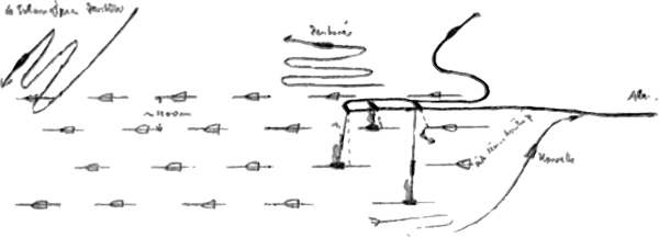
| 21.28 | Convoy in sight. Has turned to 270°. I am positioned astern. Attempt to get ahead. Must constantly outmaneuver 2 destroyers. Do not succeed in getting ahead. Now proceed from astern between the columns and operate on the last steamers in the center column. Here there are 4 large tankers. Now I am safe from destroyers who are positioned outside. Moved ahead at GF to target angle 80°. Turned towards at KF. | ||||
| 23.57 | 2 Etos shot from tubes IV and II at 10000 GRT tanker and 6000 GRT freighter. | ||||
| 23.58 | |||||
| 24.00 | DT 2623 | 1 Eto on 8000 GRT tanker. Due to operating error the shot was taken late, after the first had hit. The tanker turned away. Torpedo passed by. After 2 Min 58 seconds impact and 1 second later detonation is heard. In the outer port column saw a black explosive cloud, thereupon 2 white lights of night lifebuoys. Therefore an accidental hit. Because I could not make out the steamer perfectly, I guess 4000 GRT. I had not observed smaller steamers in the convoy. Sinking was not observed, but likely. Hit at the location of the stack. | |||
| NbyE 1, 2/10, Sea 1, Vis. 12 nm, dark night | |||||
| Freighter was hit amidships, immediate heavy list, after 1-1/2 minutes boiler explosion, bright firey glow, sank after 5 minutes. Range = 600 meters, target angle 80°. | |||||
| Tanker hit amidships, high explosion column, breaks in the center. Both ends tilt towards, sinking not observed. Shoots 2 light rockets. Range = 1700 meters, target angle 90°, Type: "CANADOLITE" 11,309 GRT. | |||||
|
Sun and Moon Data 27.06.41 |
- 14 - |
|||||
| continued: | |||||
| 27.06.41 | |||||
| Made off astern, when a corvette, the port astern sweeper, approached me. Both engines AK. Was shot at by the last merchant steamer with artillery. Began to think that the corvette no longer sees me, when he suddenly throws a light buoy, sets masthead lanterns and closes in the wake at target angle 0°. | |||||
| 4 stack destroyer | destroyer crash dive! | ||||
 |
|||||
| distance about 1100 meters | artillery fire corvette | ||||
| 28.06.41 | |||||
| 00.14 | |||||
| 02.15 | |||||
| 05.27 | Convoy in sight 60° to starboard. It is already too bright for a new night attack. Ran at highest speed to be at the limit of visibility when it gets light. Convoy steers course 280°. | ||||
| 07.19 | |||||
| 08.26 | NNW 0-1, 1/10, Sea 0, Vis. 15 nm | ||||
| 09.20 | Convoy again in sight. His course is now 310°. An adjusted contact keeper report is not sent. | ||||
| 10.14 | |||||
| 10.20 | DT 2247 | 4 aircraft bombs, well placed in direction, heavy concussions in the boat, no damage except for Papenburg depth gauge glass. I am amazed given the depth. Believe that he saw the diving location with the flat as glass sea by the disturbance from venting. I believe direct sighting of the boat is not possible. Went to depth T = 40 meters. [actual depth 80 meters] | |||
| 10.30 | 2 bombs further off. | ||||
|
Sun and Moon Data 27.06.41 |
| Sun and Moon Data 28.06.41 |
- 15 - |
|||||
| continued: | |||||
| 28.06.41 | |||||
| 11.24 | 11 depth charges. Destroyer sounds. Depth T = 65 meters. [actual depth 130 meters] Up to 12.15 hours 53 depth charges. The first well placed, then further off, the last again surprisingly well placed. No damage. | ||||
| 12.00 | DT 2247 | Day's run: 230 nm | |||
| total: 3362 nm | |||||
| of that:
80 nm |
|||||
| 15.56 | DT 2246 | ||||
| NbyW 0-1, 2/10, Sea 0, Vis. 20 nm | |||||
| 16.00 | DT 2246 | ||||
| As above | |||||
| 16.25 | Sent Radio Message: "Convoy 11.30 hours (DGZ) DT 2246, 300°, forced off, aircraft bombs and depth charges, in pursuit." Operating on general course 310° and 300°. Up to darkness nothing seen. | ||||
| 20.00 | DG 9898 | ||||
| As above | |||||
| 23.15 | From plotting must be at the convoy position. |
||||
| 23.55 | DG 9872 | ||||
| NbyW 1, 4/10, Sea 1, Vis. 15 nm | |||||
|
|
|||||
| 29.06.41 | |||||
| 04.00 | DG 9761 | ||||
| As above | |||||
| 07.05 | Sunderland in sight bearing 80°T. Flies off. This confirms my suspicion that the convoy is located to the NE of us. | ||||
| 08.00 | DG 9721 | ||||
| NNE 1, 4/10, Sea 0-1, Vis. 20 nm | |||||
| 11.42 | Convoy in sight. 4 smoke clouds far apart. It is positioned exactly on the plotted general course approximately 5 nm ahead of where I have plotted for 24 hours. I am glad to have contact again after 25 hours. | ||||
| 12.00 | DC 9428 | Day's run: 224 nm | |||
| NNW 1, 3/10, Sea 1-2, Vis. 25 nm | total: 3586 nm | ||||
| of that:
92 nm |
|||||
| 12.15 | Presented Radio Message: ". . . . . . . . square DG 9240 several independents, course 345°, U-103". Suppose that at night faster steamers have detached from the convoy to proceed as independents. Plot them at 10 knots. Tendency of the convoy is again to the north. | ||||
| 12.25 | Sent Radio Message: "Enemy convoy in sight square DG 9421, course 315°, 7 knots, wide formation". | ||||
| Signal was not understood. | |||||
| 13.29 | Sent again. Was understood. A steamer sweeps ahead of the convoy, at times bow right, at times bow left. Initially suspect a destroyer. | ||||
| 14.00 | Pushes ahead far to the west and forces me off. Hold contact on him. Convoy is lost from sight. | ||||
|
Sun and Moon Data 28.06.41 |
| Sun and Moon Data 29.06.41 |
- 16 - |
|||||
| continued: | |||||
| 29.06.41 | |||||
| Seems to be a freight steamer, because he smokes frequently and heavily. Suppose a U-boat trap or an auxiliary cruiser, far on the port side of the convoy making an advance to detect and to draw submarines to itself or to force them to submerge. Zig zags 60° very irregularly and frequently all for 5 to 10 minutes, getting ahead is difficult and time consuming. | |||||
| 16.00 | DG 8391 | ||||
| NNW 2, 4/10, Sea 2, Vis. 22 nm | |||||
| 18.00 | Positioned ahead of his general course of about 305°. His speed was plotted at 10 knots. | ||||
| 18.31 | |||||
| 19.36 | DG 8316 | Shortly before shooting the steamer changes course from 270° to 315°. Can just barely run off at HF and shoot stern shot from range = 350 meters, target angle 85°. [Steamer] Seems to run faster, fired at forward mast. Hit at the bridge. High water column. Bright firey glow. On the chart house the name: "RIO AZUL", 4088 GRT. From the gaff the War Flag. Gray warship painting. The stern platform has 2 cannons, approximately 7.6 cm, 2 depth charge throwers. People move to the stern to the cannons. Steamer collapses in the middle. The forship sinks. Stern rights itself. Gun's crew slides to the center. Stern with running screw into the deep. Total time: 2-1/2 minutes. On the bridge wings 2 cm. On the forecastle probably a cannon, not exactly recognized. On each side 2 boats swung out. Smashed. | |||
| 19.40 | |||||
| 20.00 | Course 60° to the convoy. | ||||
| 20.45 | Sent Radio Message: "Forced off by auxiliary cruiser "RIO AZUL". Sunk. In pursuit. DG 8327". | ||||
|
Sun and Moon Data 29.06.41 |
- 17 - |
|||||
| continued: | |||||
| 29.06.41 | |||||
| Evening navigation fix showed 12 nm shift to the NW. Therefore, the true location was: DG 8316. No contact up to darkness. At 24.00 am positioned at the supposed location of the convoy. Proceeded on course 320° to search for contact again during the day. | |||||
| 24.00 | DG 5982 lower-right corner | ||||
| NNW 1, 5/10, Sea 1-2, Vis. 5 nm | |||||
|
|
|||||
| 30.06.41 | |||||
| 04.00 | DG 5918 | ||||
| NNW 2, 7/10, Sea 2, Vis. 5 nm | |||||
| 08.00 | DG 5593 | Suspect that the convoy has a northerly general course and search in 5° increments up to 345°. | |||
| NNE 2, 7/10, Sea 2, Vis. 10 nm | |||||
| 12.00 | DG 5379 | Day's run: 254 nm | |||
| N 2, 8/10, Sea 2, Vis. 15 nm sometimes reduced to 4 nm in thunderstorms | total: 3840 nm | ||||
| of that:
96 nm |
|||||
| Up to now nothing seen. Came to 270°, later 250° because yesterday evening the convoy may have made an evening change of course to the west again and the auxiliary cruiser was searching ahead in that direction. I must now cross all possible courses. Unfortunately, visibility is heavy deteriorated in thunder storms, so that I can easily pass by. | |||||
| 16.00 | DG 5551 | ||||
| As above | |||||
| 20.00 | DG 5458 | Running on plotted general course of 315°. | |||
| NNW 2, 9/10, Sea 2, Vis. 20 nm | |||||
| 21.00 | Sent Radio Message: "33 hours with no contact. Question continuing southern transit. DG 5473." | ||||
| 24.00 | DG 5187 | ||||
| NW 2, 3/10, Sea 1-2, Vis. 20 nm | |||||
|
|
|||||
| 01.07.41 | |||||
| 04.00 | DG 5147 | ||||
| As above | |||||
| 08.00 | DG 4362 | ||||
| N 1, 7/10, Sea 1-2, Vis. 20 nm | |||||
| 08.45 | Presented Radio Message: "To U-123, U-66. Continue southern transit. . . . . . . . ." | ||||
| 09.00 | On course 140°. | ||||
| I regret not gaining contact again on the 4th day. It is possible that the convoy scattered due to attacks of U-69 and me, | |||||
|
Sun and Moon Data 01.06.41 |
| Sun and Moon Data 02.06.41 | |
| Sun and Moon Data 01.07.41 |
- 18 - |
||||||||||||||||||||
| continued: | ||||||||||||||||||||
| 01.07.41 | ||||||||||||||||||||
| and got together again later. This is indicated by the independent steamers reported by U-103 which undoubtedly came from the convoy. Success from this convoy: | ||||||||||||||||||||
|
||||||||||||||||||||
| 12.00 | DG 4365 | Day's run: 254 nm | ||||||||||||||||||
| NE 2, 6/10, Sea 1, Vis. 20 nm | total: 4094 nm | |||||||||||||||||||
| of that:
96 nm |
||||||||||||||||||||
| 16.00 | DG 5175 | |||||||||||||||||||
| NNE 1, 6/10, Sea 1, Vis. 25 nm | ||||||||||||||||||||
| 20.00 | DG 5424 | |||||||||||||||||||
| ENE 1, 5/10, Sea 1, Vis. 25 nm | ||||||||||||||||||||
| 24.00 | DG 5467 | |||||||||||||||||||
| ENE 1, 9/10, Sea 1, Vis. 5 nm, moonshine | ||||||||||||||||||||
|
|
||||||||||||||||||||
| 02.07.41 | ||||||||||||||||||||
| 04.00 | DG 5499 | Presented Officer-Only Radio Message: "From U-66, square DG 60, 3 steamers, 16240 GRT, square DG 26 one steamer damaged in artillery combat. . . . . " | ||||||||||||||||||
| ENE 1, 9/10, Sea 1, Vis. 5 nm | ||||||||||||||||||||
| These 4 steamers certainly came from our convoy which had temporarily scattered. U-66 pushed ahead on the basis of my messages, must have come to this conclusion, and should have reported enemy contact by radio signal. I was positioned nearby and would then have advanced further to the NE instead of searching to the W. Regaining contact on part of the convoy would have been likely. In any case because boats in the area report repeatedly, absolute radio silence was not required. A more meaningful co-operation would have been more helpful to the overall operation. | ||||||||||||||||||||
| 08.00 | DG 5818 | |||||||||||||||||||
| NEbyE 2, 2/10, Sea 1-2, Vis. 20 nm | ||||||||||||||||||||
| 09.42 | ||||||||||||||||||||
| 10.37 | ||||||||||||||||||||
| 10.55 | ||||||||||||||||||||
| 11.01 | ||||||||||||||||||||
| 11.04 | ||||||||||||||||||||
| 11.25 | ||||||||||||||||||||
|
Sun and Moon Data 01.07.41 |
| Sun and Moon Data 02.07.41 |
- 19 - |
|||||
| continued: | |||||
| 02.07.41 | |||||
| 12.00 | DG 5857 | Day's run: 150 nm | |||
| ENE 1, 8/10, Sea 1, Vis. 25 nm | total: 4244 nm | ||||
| of that 104
nm |
|||||
| 16.00 | DG 5897 | ||||
| As above | |||||
| 20.00 | DG 8263 | ||||
| As above | |||||
| 24.00 | DG 8372 | ||||
| EbyN 1, 9/10, Sea 1, Vis. 8 nm | |||||
|
|
|||||
| 03.07.41 | |||||
| 04.00 | DG 8627 | ||||
| ENE 1, 7/10, Sea 1, Vis, 5 nm | |||||
| 08.00 | DG 8667 | ||||
| ENE 1, 5/10, Sea 1, Vis. 20 nm | |||||
| 12.00 | DG 8699 | Day's run: 156 nm | |||
| NNE 1, 1/10, Sea 1, Vis. 25 nm | total: 4400 nm | ||||
| of that 104
nm |
|||||
| New course 205°. | |||||
| 16.00 | DG 8962 | ||||
| NNE 2, 2/10, Sea 1-2, Vis. 25 nm | |||||
| 16.58 | Smoke cloud astern to starboard. Ran towards. Steamer has two masts, one stack, heavy zig-zags around general course 215°, 40° to either side. Maneuvered ahead on general course. | ||||
| 19.39 | DG 8959 | ||||
| 21.29 | Bright moonshine | ||||
| 24.00 | DT 1117 | ||||
| NNE 1, 7/10, Sea 1, Vis. 5 nm | |||||
|
|
|||||
| 04.07.41 | |||||
| 02.45 | Moon has set. To Action Stations. Because it is now very dark, if I did not extend too far. At target angle 90° I initially had range = 2000 meters. Turn away again on parallel course and move further ahead. Because I was not sure of his speed (he actually ran at 12 knots) I must go closer. At target angle 50° turned towards again. | ||||
|
Sun and Moon Data 02.07.41 |
| Sun and Moon Data 03.07.41 | |
| Sun and Moon Data 04.07.41 |
- 20 - |
|||||
| continued: | |||||
| 04.07.41 | |||||
| 03.55 | DS 3387 lower-right | Shot, 1 Ato from tube III. Range = 1000 meters, target angle 90°, target speed = 11 knots. Enemy just fills the periscope. After 63 seconds hit forward edge of the after mast. Heavy bang, light explosion column. Steamer settles astern. On 600 meter sends: "SSS, AUDITOR g k m j, 25.47N, 28.25W torpedo." This position is only 6 nm from our plot. Steamer remains with the stern at the waterline. 2 boats are launched. After 20 minutes the stern suddenly settles deeper. When smoke stack dips, white steam cloud. No fires. Bow rises steeply. After 23 minutes he has sunk. "AUDITOR", 5444 GRT, Liverpool. On old course 205°. | |||
| 08.00 | DS 3642 | ||||
| N 2, 4/10, Sea 2, Vis. 20 nm | |||||
| 12.00 | DS 3596 | Day's run: 208 nm | |||
| NbyE 2, 2/10, Sea 2, Vis. 20 nm | total: 4608 nm | ||||
| of that 109
nm |
|||||
| 16.00 | DS 3837 | ||||
| NbyE 2, 3/10, Sea 2, Vis. 25 nm | |||||
| 20.00 | DS 3882 | ||||
| N 2-3, Sea 3/10, Sea 3, Vis. 20 nm | |||||
| 24.00 | DS 6216 | ||||
| NNE 1, 7/10, Sea 2, Vis. 5 nm |
|
||||
| 05.07.41 | |||||
| 04.00 | DS 6247 | Passed the Tropic of Cancer. | |||
| NNE 1, 3/10, Sea 1, Vis. 5 nm | |||||
| 08.00 | DS 6432 | On course 125°. | |||
| NNE 1-2, 3/10, Sea 1-2, Vis. 20 nm | |||||
| 12.00 | DS 6519 | Day's run: 156 nm | |||
| As above | total: 4764 nm | ||||
| of that 109
nm |
|||||
| 16.00 | DS 6567 | ||||
| " " | |||||
| 17.13 | |||||
| 17.28 | |||||
| 20.00 | DS 6595 | ||||
| NE 2-3, 4/10, Sea 2, Vis. 20 nm | |||||
| 24.00 | DS 6913 | ||||
| NEbyN 3, 6/10, Sea 2-3, Vis. 8 nm |
|
||||
| 06.07.41 | |||||
| 04.00 | DS 6961 | ||||
| NNE 2, 2/10, Sea 1, Vis. 5 nm | |||||
| 08.00 | DT 4747 | ||||
| NEbyE 2, 3/10, Sea 1-2, Vis. 20 nm | |||||
| 10.00 | On course 235°. | ||||
| 12.00 | DS 4777 | Day's run: 155 nm | |||
| " | total: 4919 nm | ||||
| of that 110
nm |
|||||
| 16.00 | DS 9334 | ||||
| " | |||||
| 20.00 | DS 9346 | ||||
| " | |||||
| 24.00 | DS 9292 | ||||
| " |
|
||||
|
Sun and Moon Data 04.07.41 |
| Sun and Moon Data 05.07.41 | |
| Sun and Moon Data 06.07.41 |
- 21 - |
|||||
| 07.07.41 | |||||
| 04.00 | DS 9521 | ||||
| NEbyE 2, 4/10, Sea 2, Vis. 15 nm | |||||
| 08.00 | DS 9439 | ||||
| NE 3, 5/10, Sea 3, Vis. 20 nm | |||||
| 12.00 | DS 9459 | Day's run: 156 nm | |||
| NE 3, 5/10, Sea 3, Vis. 20 nm | total: 5075 nm | ||||
|
of that 110 nm |
|||||
| New course 115°, intend to make for the Cape Verde Islands to check traffic there. | |||||
| 12.34 | |||||
| 12.53 | |||||
| 16.00 | DS 9493 | ||||
| ENE 3-4, 4/10, Sea 3, Vis. 20 nm | |||||
| 20.00 | DS 9733 | Strong off set to the west. | |||
| 24.00 | DS 9816 | ||||
| NE 4, 2/10, Sea 3-4, Vis. 8 nm |
|
||||
| 08.07.41 | |||||
| 04.00 | DS 9861 | ||||
| NE 4, 5/10, Sea 4, Vis. 5 nm | |||||
| 08.00 | DS 9945 | ||||
| NE 5, 4/10, Sea 4, Vis. 15 nm | |||||
| 12.00 | DS 9983 | Day's run: 145 nm | |||
| " | total: 5220 nm | ||||
|
of that 111.5 nm |
|||||
| 16.00 | DS 9996 | ||||
| " | |||||
| 20.00 | EJ 1115 | ||||
| " | |||||
| 24.00 | EJ 1126 |
|
|||
| " | |||||
| 09.07.41 | |||||
| 04.00 | EJ 1163 | ||||
| NE 3-4, 4/10, Sea 3-4, Vis. 8 nm | |||||
| 08.00 | EJ 1246 | ||||
| 12.00 | EJ 1259 | Day's run: 120 nm | |||
| NE 3-4, 7/10, Sea 3, Vis. 20 nm | total: 5340 nm | ||||
| of that 111.5
nm |
|||||
| 16.00 | EJ 1374 | ||||
| 20.00 | EJ 1378 | ||||
| 24.00 | EJ 1622 |
|
|||
| 10.07.41 | Cape Verde | ||||
| 04.00 | EJ 1635 | ||||
| NE 2, 9/10, Sea 2-3, Vis. 5 nm | |||||
| 07.30 | San Antão in sight ahead to starboard, 20 nm distant. | ||||
| 08.00 | EJ 2418 | ||||
| 12.00 | EJ 2453 | Day's run: 120 nm | |||
| NEbyN 3, 10/10, Sea 2-3, Vis. 20 nm | total: 5460 nm | ||||
| of that 111.5
nm |
|||||
| 16.00 | EJ 2466 | New course 125°. | |||
| 20.00 | EJ 2573 | ||||
| NE 3, 6/10, Sea 2-3, Vis. 20 nm | |||||
| 24.00 | EJ 2588 | ||||
| NE 2, 7/10, Sea 2, Vis. 5 nm |
|
||||
| 11.07.41 | |||||
| 04.00 | EJ 2835 | New course 180°. | |||
| NE 3, 8/10, Sea 2-3, Vis. 5 nm | |||||
| 07.48 | A steamer ahead to starboard, course about 55°. Came to 30°, maneuvered ahead. | ||||
|
Sun and Moon Data 07.07.41 |
| Sun and Moon Data 08.07.41 | |
| Sun and Moon Data 09.07.41 | |
| Sun and Moon Data 10.07.41 | |
| Sun and Moon Data 11.07.41 |
- 22 - |
|||||
| continued: | |||||
| 11.07.41 | |||||
| 08.00 | EJ 2865 | ||||
| NE 3-4, 8/10, Sea 3, Vis. 15 nm | |||||
| 09.38 | |||||
| 11.58 | EJ 2917 | ||||
| NEbyN 3, 9/10, Sea 3, Vis. 15 nm | Day's run: 120 nm | ||||
| total: 5580 nm | |||||
| of that 116.5
nm |
|||||
| 16.00 | EJ 2899 | ||||
| 18.00 | New course 240°. | ||||
| 20.00 | EJ 5226 | Received Radio Message concerning assigned operations area north of "Point Anton". [Point Anton = Freetown] | |||
| 24.00 | EJ 5245 | ||||
| NEbyN 3, 7/10, Sea 2-3, Vis. 5 nm | |||||
|
|
|||||
| 12.07.41 | |||||
| 04.00 | EJ 5192 | ||||
| 08.00 | EJ 5187 | ||||
| NE 3, 6/10, Sea 2-3, Vis. 20 nm | |||||
| 12.00 | EJ 4636 | New course 140°. | |||
| Day's run: 152 nm | |||||
| total: 5732 nm | |||||
| of that 116.5
nm |
|||||
| 16.00 | EJ 4669 | ||||
| 20.00 | EJ 5715 | ||||
| 24.00 | EJ 5733 | ||||
| NE 2, 5/10, Sea 1-2, Vis. 5 nm | |||||
|
|
|||||
| 13.07.41 | |||||
| 04.00 | EJ 5792 | ||||
| 08.00 | EJ 8212 | ||||
| NEbyN 2, 6/10, Sea 1-2, Vis. 15 nm | |||||
| 12.00 | EJ 8252 | Day's run: 144 nm | |||
| NE 2, 7/10, Sea 2, Vis. 15 nm | total: 5876 nm | ||||
| of that 116.5
nm |
|||||
| New course 155°. | |||||
| 16.00 | EJ 8286 | ||||
| NE 3, 7/10, Sea 2-3, Vis. 20 nm | |||||
| 16.58 | |||||
| 17.18 | |||||
Message from B.d.U. concerning U-123's operational area as recorded in U-66's KTB
| 21.40 | Radio Message 2058/11/130 | ||||
| To southern boats. | |||||
| Boundary: in the Kriegsmarine Order Paragraph IVB named place [Freetown] is to bear 40°. UA operates south of this line, U-66 and U-123 north of it. The greatest chances for success are believed to be close to the place, possibly on the 200-meter line. | |||||
|
Sun and Moon Data 11.07.41 |
| Sun and Moon Data 12.07.41 | |
| Sun and Moon Data 13.07.41 |
- 23 - |
|||||
| continued: | |||||
| 13.07.41 | |||||
| 19.45 | Presented Radio Message, that there are no attack area restrictions for U-boats to the west within the borders of the operations area. Nevertheless, initially I intend to go to point "Anton" to detect traffic expected to be there on the 200-meter line. Even if "U-A" found nothing there for 14 days, it may be that this was only a temporary diversion of traffic. After one week if there is no traffic, I intend to march in long legs to the west, up to the western border of the operations area to detect traffic frequently found there. At the same time there I will be close to the supply point, because I must supply in not later than 3 weeks. | ||||
| 20.00 | EJ 8538 | ||||
| NE 2, 9/10, Sea 1-2, Vis. 15 nm | |||||
| 22.19 | Rain squalls, Vis. 1-2 nm | An illuminated steamer to starboard, course 25°, about 4500 GRT. Passed by at range = 300 meters. Neutrality not recognized with certainty. Seems to have an illuminated banner on the stern. Steamed in the wake under the cover of a thick rain squall and closed. At range = 75-100 meters offset to port and starboard. Banner has Spanish colors. Also has a flag and name painted on the side of the hull. People standing at the rail were clearly visible with the naked eye. Because we were positioned in black rain squall and he is blinded by own light to the stern, he cannot see us at this short range. | |||
| 24.00 | EJ 8618 | ||||
| ESE 2, 10/10, Sea 1-2, heavy rain | |||||
|
|
|||||
| 14.07.41 | |||||
| 00.44 | After neutrality was recognized with certainty, turned off on old course 155°. | ||||
| 04.00 | EJ 8654 | ||||
| Wind calm, 6/10, Sea 0, Vis. 3 nm | |||||
| 08.00 | EJ 8689 | Course 100°. | |||
| ENE 1, 9/10, Sea 1, Vis. 15 nm | |||||
| 12.00 | EJ 9711 | Day's run: 158 nm | |||
| NEbyN 1, 7/10, Sea 1, Vis. 15 nm, long swells | total: 6034 nm | ||||
| of that 118
nm |
|||||
Message concerning UA's experience as recorded in U-66's KTB
| 13.07.41 | |||||
| 05.22 | Radio Message to B.d.U. | ||||
| Since 01 July at point "Ida" also on the 200-meter line neither traffic nor air reconnaissance met. Delayed transit to the north. Square ET 2760. UA | |||||
|
Sun and Moon Data 13.07.41 |
| Sun and Moon Data 14.07.41 |
- 24 - |
|||||
| continued: | |||||
| 14.07.41 | |||||
| 16.00 | EJ 9722 | ||||
| NbyE 2, 5/10, Sea 1, Vis. 20 nm | |||||
| 20.00 | EJ 9842 | ||||
| 24.00 | EJ 9852 | ||||
| NbyE 1, 6/10, Sea 1, Vis. 2-3 nm | |||||
|
|
|||||
| 15.07.41 | |||||
| 04.00 | EJ 9866 | ||||
| 08.00 | EJ 9958 | ||||
| N 2, 7/10, Sea 1-2, Vis. 15 nm | |||||
| 12.00 | EJ 9993 | Day's run: 156 nm | |||
| NbyW 2, 7/10, Sea 1-2, Vis. 20 nm | total: 6190 nm | ||||
| of that 118
nm |
|||||
| 16.00 | EK 7781 | ||||
| 20.00 | EK 7796 | ||||
| N 1, 5/10, Sea 1, Vis. 20 nm | |||||
| 24.00 | EK 7887 | ||||
| NbyE 1, 1/10, Sea 0-1, Vis. 5 nm | |||||
|
|
|||||
| 16.07.41 | |||||
| 04.00 | EK 7898 | ||||
| Still, 2/10, Sea 0, Vis. 5 nm | |||||
| 08.00 | ET 1321 | ||||
| SSE 0-1, 3/10, Sea 0-1, Vis. 25 nm | |||||
| 12.00 | ET 1335 | Day's run: 156 nm | |||
| SEbyS 1-2, 4/10, Sea 1, Vis. 25 nm | total: 6346 nm | ||||
| of that 118
nm |
|||||
| 16.00 | ET 2119 | ||||
| 17.58 | |||||
| 18.16 | |||||
| 20.00 | ET 2127 | New course 135°. | |||
| 24.00 | ET 2167 | ||||
|
|
|||||
| 17.07.41 | |||||
| 04.00 | ET 2277 | ||||
| SSE 2, 5/10, Sea 1-2, Vis. 4 nm | |||||
| 05.00 | New course 145°, positioned on the 200-meter line. It becomes shallow very quickly here, sounded 50 meters. | ||||
| 08.00 | ET 2519 | New course 120°. Proceeding on the 200-meter line. | |||
| 12.00 | ET 2564 | Day's run: 143 nm | |||
| SbyW 3-4, 8/10, Sea 3, Vis. 10 nm, frequent rain showers | total: 6489 nm | ||||
| of that 119
nm |
|||||
| 16.00 | ET 2671 | ||||
| 19.00 | A steamer 2 points to starboard, 1 smokestack, 2 masts, heavy cargo derricks ahead of the mast, topped for heavy cargo. Well positioned ahead. Ran along, until it is completely dark. Steamer on course 275°, 12 knots, comes from Freetown. With darkness I notice that he proceeds illuminated. I had not expected this, because he must have come from Freetown. | ||||
| 20.00 | ET 2678 | Turned towards him and ran directly ahead. A U.S.A. ship, about 6,500 GRT, heavily | |||
| SWbyS 3, 9/10, Sea 3, Vis. 3 nm | |||||
|
Sun and Moon Data 14.07.41 |
| Sun and Moon Data 15.07.41 | |
| Sun and Moon Data 16.07.41 | |
| Sun and Moon Data 17.07.41 |
- 25 - |
|||||
| continued: | |||||
| 17.07.41 | |||||
| loaded, black smokestack, wide red ring set off by 2 narrow white stripes appearing like the "Luckenbach Line", however the "L" of the shipping company was not seen on the smokestack. The clearly visible flag is painted on the side of the hull and brightly illuminated by floodlights. The flag flew astern, also brightly illuminated by floodlight. Because he yawed heavily, I suddenly approached to 200-250 meters and for a short time stood in the light of the stern floodlight. People could be observed in the brightly illuminated side deck however, they had to be blinded. It is a very dark night, pitch-black rain squall as a background. I can hardly believe that he has sighted us. | |||||
| 20.48 | New course 110°. I still hope to meet other steamers. However, perhaps the English take advantage of the current political situation and allow ships to proceed under the U.S.A. Flag, because that is currently the best life insurance | ||||
| 22.45 | Presented Radio Message: "To southern boats, . . . . . . . . currently no supply beyond own bases is possible. Begin return transit accordingly. . . . . . . ." | ||||
| Bad news, especially since only neutrals go here. It is fortunate that we have been stingy with the fuel. Inventory: 109 cbm still 6 Etos and 5 Atos. I can still stay out 5-6 weeks and hope to make good use of the torpedoes. Perhaps by then the supply situation will change again. | |||||
| 24.00 | ET 2921 | ||||
| SSW 3, 6/10, Sea 2, Vis. 4 nm | |||||
|
|
|||||
| 18.07.41 | |||||
| 02.19 | 1 point to port, 2 black shadows. Turned away hard, keeping them astern. Typical warship silhouette. One certainly a destroyer, the other seems larger, suspect a light cruiser. Running at high speed, bow and stern wake can be seen clearly. Running on | ||||
|
Sun and Moon Data 17.07.41 |
| Sun and Moon Data 18.07.41 |
- 26 - |
|||||
| continued: | |||||
| 18.07.41 | |||||
| changing courses between 290° and 220°. All torpedo armament ready, both were out of sight again. In pursuit in the direction of the last bearing, at 03.00 hours the enemy comes in sight again. I do not succeed in reaching a shooting position, because the night is very dark and they are lost from sight again. At 03.20 hours again in sight, but very blunt target angle. Distinguished perfectly as warships. | |||||
| 03.34 | Both out of sight, came to course 300° and ran off. It seems to be a search group which perhaps, was looking on behalf of the Yankee. Where warships are looking for submarines, there must also be merchant vessels which must be protected. Will push ahead by day on these courses in the direction of Freetown. | ||||
| 04.00 | ET 2926 | ||||
| SSW 2, 9/10, Sea 1-2, Vis. 4 nm | |||||
| 08.00 | ET 2675 | ||||
| 11.30 | New course 150°. | ||||
| 12.00 | ET 2592 | Day's run: 156 nm | |||
| SSW 3, 6/10, Sea 2, Vis. 20 nm | total: 6645 nm | ||||
| of that 119
nm |
|||||
| 15.00 | New course 95°. | ||||
| 16.00 | ET 2671 | Navigation correction of 16 nm NbyW. A strong current runs here to the north, so that one can only rely on the depth sounder for navigation, about 18.00 hours the sea was almost covered with barrels, amongst wreckage. Already heavily encrusted with mussels. A barrel was fished out. It contained butter which however, was already rancid, and only partly edible. A predecessor has dealt the English butter supply a serious blow. | |||
| 18.51 | |||||
| 19.06 | |||||
| 20.00 | ET 2681 | ||||
| SbyW 2-3, 7/10, Sea 2, Vis. 15 nm | |||||
| 20.22 | A light bearing 10°T. Turned towards and closed at high speed. | ||||
| 20.58 | Range 500 meters, again the steamer is a U.S.A. ship. About 6500 GRT. | ||||
|
Sun and Moon Data 18.07.41 |
- 27 - |
|||||
| continued: | |||||
| 18.07.41 | |||||
| On the hull the flag is illuminated by floodlight. Astern an illuminated banner. Proceeding in ballast. Took position in the wake and followed. His course 115° goes exactly to Freetown. | |||||
| 23.48 | 2 destroyers in sight astern. Again one is particularly large. It seems to be the same group from yesterday. It may not be the size of a small cruiser but instead a torpedo boat destroyer of the "LE FANTASQUE" class in English hands. | ||||
| 24.00 | ET 2691 | ||||
|
|
|||||
| 19.07.41 | |||||
| I had to haul out to the north and followed a curved path to a reciprocal heading while slowly increasing speed. The destroyers steered changing courses with general course behind the U.S.A. ship. Distance about 7-8 nm. Yesterday and today the lowest range of the destroyers was 2500-3000 meters. Because I was in shallow water (65 meters), I turned to the south and quickly came to greater depths. One destroyer had briefly shown a light, probably on the bridge someone had carelessly opened a bulkhead. The shadow, bow and stern wake could be seen with the naked eye. It shows once again that the enemy, by being on the defensive is at a disadvantage, because with a little bit more attention he would also have seen our stern wake. Because we are always on the attack, we had to recognize the enemy earlier. | |||||
| 00.45 | Both destroyers out of sight. | ||||
| 04.00 | ET 2678 | ||||
| SSW 2, 2/10, Sea 2, Vis. 5 nm | |||||
| 07.00 | New course 335°. Intend to operate on the discovered route to find traffic there. | ||||
| 10.00 | Received Radio Message: "To U-123, U-66, report situation in operations area, . . . . . . . . ". | ||||
|
Sun and Moon Data 18.07.41 |
| Sun and Moon Data 19.07.41 |
- 28 - |
|||||
| continued: | |||||
| 19.07.41 | |||||
| 12.00 | ET 2529 | Day's run: 157 nm | |||
| SSW 2, 4/10, Sea 2, Vis. 25 nm | total: 6802 nm | ||||
| of that 120
nm |
|||||
| 16.00 | ET 2515 | New course 125°. | |||
| 20.00 | ET 2553 | New course 100°, running along the edge of the 100-meter line. | |||
| SbyE 2, 4/10, Sea 1, Vis. 5 nm | |||||
| 22.40 | Ray of light bearing 200°T. Turned at high speed to maintain contact. Again a brightly lit steamer about 7000 GRT. Course 105° proceeding direct to Freetown. Speed 15-16 knots. I am soon positioned astern and do not approach any closer than range = 2000 meters. The U.S.A. flag was clearly recognizable on the side of the hull. | ||||
| 24.00 | ET 2677 | ||||
| WbyS 2-3, 1/10, Sea 2, Vis. 3 nm | |||||
|
|
|||||
| 20.07.41 | |||||
| 00.25 | New course 255°. Again astern there was a brief shadow and light. So the same magic. There is nothing to be gained here, I move my operations area to the west. It is a bitter feeing to watch as the Englishman apparently lets his ships proceed as U.S.A. ships because he knows that we do not attack. At the same time he uses them as a lure for submarines and performs a U-boat hunt with destroyers. I was not allowed to attack these destroyers, although twice the opportunity was very favorable for a stern shot. | ||||
| 01.21 | Sent Radio Message: "From U-123, "AUDITOR" sunk. In EJ neutral traffic, off Point Anton heavy inbound and outbound independent traffic of U.S.A. ships, on entrance route daily U-boat hunt by destroyer groups." I was only in the operations area 3 days, but we did not need to complain about boredom. | ||||
| 04.00 | ET 2597 | ||||
| WSW 2, 1/10, Sea 1-2, Vis. 4 nm | |||||
| 08.00 | ET 2574 | ||||
| 12.00 | ET 2489 | Day's run: 167 nm | |||
| WSW 2-3, 0/10, Sea 2, Vis. 25 nm | total: 6969 nm | ||||
| of that 120
nm |
|||||
|
Sun and Moon Data 19.07.41 |
| Sun and Moon Data 20.07.41 |
- 29 - |
|||||
| continued: | |||||
| 20.07.41 | |||||
| 12.30 | Presented Radio Message: "To U-66, U-123, operations area in the "Cape Verde" sea area to the east of 30°W, if opportunity for success appear low off Point Anton. Concentration of traffic probably in the west." We were already on the way to the new hunting ground. | ||||
| 14.34 | |||||
| 15.21 | |||||
| 16.00 | ET 2712 | ||||
| WSW 2, 2/10, Sea 2, Vis. 25 nm | |||||
| 20.00 | ET 1934 | ||||
| As above, Vis. 10 nm | |||||
| 24.00 | ET 1919 | ||||
| " " Vis 5 nm | |||||
|
|
|||||
| 21.07.41 | |||||
| 04.00 | ET 1862 | ||||
| WNW 2, 1/10, Sea 1-2, Vis. 4 nm | |||||
| 08.00 | ET 1854 | ||||
| 12.00 | ET 1792 | Day's run: 153 nm | |||
| W 3, 7/10, Sea 2, Vis. 25 nm | total: 7122 nm | ||||
| of that 122.5
nm |
|||||
| 16.00 | ET 4121 | ||||
| 17.23 | |||||
| 17.33 | |||||
| 20.00 | ES 6336 | ||||
| SW 2, 6/10, Sea 1-2, Vis. 10 nm | |||||
| 24.00 | ES 6328 | ||||
|
|
|||||
| 22.07.41 | |||||
| 04.00 | ES 6341 | ||||
| W 2-3, 7/10, Sea 2, Vis. 3 nm | |||||
| 08.00 | ES 6255 | ||||
| 12.00 | ES 6247 | Day's run: 155 nm | |||
| SWbyW 4, 7/10, Sea 3, Vis. 20 nm | total: 7277 nm | ||||
| of that 123.5
nm |
|||||
| 16.00 | ES 6186 | ||||
| 20.00 | ES 6178 | New course 270°. | |||
| 24.00 | ES 6413 | ||||
| SWbyW 2, 2/10, Sea 1-2, Vis. 5 nm | |||||
|
|
|||||
| 23.07.41 | |||||
| 04.00 | ES 5632 | ||||
| SWbyW 3, 2/10, Sea 2-3, Vis. 13 nm | |||||
| 08.00 | ES 5622 | ||||
| 12.00 | ES 5611 | Day's run: 148 nm | |||
| SW 4, 4/10, Sea 3, Vis. 20 nm | total: 7425 nm | ||||
| of that 123.5
nm |
|||||
| 16.00 | ES 5523 | ||||
| 20.00 | ES 5513 | ||||
| SW 4, 10/10, Sea 3, Vis. 5 nm, rain squalls | |||||
| 24.00 | ES 5432 | ||||
|
|
|||||
|
Sun and Moon Data 20.07.41 |
| Sun and Moon Data 21.07.41 | |
| Sun and Moon Data 22.07.41 | |
| Sun and Moon Data 23.07.41 |
- 30 - |
|||||
| 24.07.41 | |||||
| 04.00 | ES 5422 | ||||
| SW 3, 9/10, Sea 2-3, Vis. 3 nm | |||||
| 08.00 | ES 5412 | ||||
| NW 3, 7/10, Sea 2-3, Vis. 10 nm | |||||
| 12.00 | ES 4631 | Day's run: 120 nm | |||
| total: 7545 nm | |||||
| of that 123.5
nm |
|||||
| 16.00 | ES 4621 | ||||
| SW 2-3, 10/10, Sea 2, Vis. 15 nm | |||||
| 17.55 | |||||
| 18.11 | |||||
| 20.00 | ES 4533 | New course 310°. | |||
| 24.00 | ES 4286 | ||||
| WSW 2-3, 4/10, Sea 2, Vis. 4 nm | |||||
|
|
|||||
| 25.07.41 | |||||
| 04.00 | ES 4249 | ||||
| SW 2-3, 4/10, Sea 2, Vis. 15 nm | |||||
| 08.00 | ES 4139 | ||||
| 12.00 | ES 4123 | Day's run: 140 nm | |||
| WSW 4, 9/10, Sea 3, Vis. 15 nm | total: 7685 nm | ||||
| of that 124.5 nm |
|||||
| 16.00 | ES 1773 | ||||
| 18.46 | Smoke cloud bearing 235°T, turned to close. | ||||
| 20.00 | ER 3993 | On old course 310°, probably an illusion, because today and during the last days there were peculiar swelling clouds on the horizon. Nothing more was seen up to darkness. | |||
| WSW 2-3, 10/10, Sea 2, Vis. 15 nm | |||||
| 24.00 | ER 3961 | ||||
|
|
|||||
| 26.07.41 | |||||
| 04.00 | ER 3924 | ||||
| WbyS 2, 6/10, Sea 1-2, Vis. 4 nm | |||||
| 08.00 | ES 1472 | After 4 days a 54 nm correction in direction 80° after a navigation fix. | |||
| 12.00 | ER 3661 | Day's run: 137 nm | |||
| SSW 1, 7/10, Sea 1, Vis. 15 nm | total: 7822 nm | ||||
| of that 124.5 nm |
|||||
| 16.00 | ER 3624 | ||||
| 20.00 | ER 3267 | ||||
| WbyN 1, 5/10, Sea 0-1, Vis. 10 nm | |||||
| 24.00 | ER 3219 | ||||
|
|
|||||
| 27.07.41 | |||||
| 04.00 | EH 9799 | ||||
| W 1-2, 4/10, Sea 1, Vis. 4 nm | |||||
| 08.00 | EH 9758 | ||||
| 10.00 | EH 9751 | Both engines stopped. As a substitute for the Crossing-the-Line Ceremony party was organized on board. A shark was caught at midday. | |||
| SSW 1, 2/10, Sea 1, Vis. 20 nm | |||||
|
Sun and Moon Data 24.07.41 |
| Sun and Moon Data 25.07.41 | |
| Sun and Moon Data 26.07.41 | |
| Sun and Moon Data 27.07.41 |
- 31 - |
|||||
| continued: | |||||
| 27.07.41 | |||||
| In the afternoon there was a big sports meet with sack races, egg-and-spoon race, sausage grab, various boat relay races etc. The stern was found out to be an ideal wave pool in the swell. Afterwards prize distribution. In the afternoon a smoke cloud was sighted which proved to be the same illusion as on 25 July. It has become apparent that such an onboard festival, during a longer patrol, particularly if for some weeks there was no further success, had a refreshing and stimulating effect on the entire crew. | |||||
| Day's run: 143 nm | |||||
| total: 7965 nm | |||||
| of that 124.5
nm |
|||||
| 20.00 | EH 9745 | New course 60°, began delayed return transit with 85 cbm. | |||
| NNE 1, 6/10, Sea 0-1, Vis. 15 nm | |||||
| 23.09 | 2 lights on the horizon for about 3 seconds bearing 160°T. Closed at high speed, because it must be a darkened ship, which was briefly lighted through negligence. | ||||
| 24.00 | EH 9756 | Because nothing could be seen and a search in the dark night promises little success, on old course 60°. | |||
| SO 1, 8/10, Sea 1-2, Vis. 3 nm, rain squalls | |||||
|
|
|||||
| 28.07.41 | |||||
| 04.00 | EH 9817 | ||||
| NO 2, 10/10, Sea 2, Vis. 3 nm | |||||
| 04.27 | A distinct light on the horizon again for a longer time bearing 330°T. Closed at high speed. Possibly it is the same steamer steering a northerly course. | ||||
| 05.00 | Course 10°, running at 10 knots, to possibly see a cloud of smoke when it gets light. | ||||
| 08.00 | EH 9571 | ||||
| NEbyE 2, 10/10, Sea 1, Vis. 6 nm, rain squalls | Nothing seen, low visibility, many rain showers, again on course 60°. | ||||
| 12.00 | EH 9555 | Day's run: 115 nm | |||
| NNE 4, 7/10, Sea 3, Vis. 20 nm | total: 8080 nm | ||||
| of that 124 nm |
|||||
| 16.00 | EH 9539 | ||||
| 18.24 | |||||
| 18.40 | |||||
| 20.00 | EH 9613 | ||||
| ENE 2, 10/10, Sea 2, Vis. 10 nm | |||||
| 24.00 | EH 9392 | New course 310°. | |||
|
|
|||||
|
Sun and Moon Data 27.07.41 |
| Sun and Moon Data 28.07.41 |
- 32 - |
|||||
| 29.07.41 | |||||
| 04.00 | EH 9352 | ||||
| NW 1-2, 4/10, Sea 1, Vis. 3 nm | |||||
| 08.00 | EH 9311 | ||||
| 12.00 | EH 6894 | Day's run: 151 nm | |||
| N 1, 7/10, Sea 1, Vis. 15 nm | total: 8231 nm | ||||
| of that 125 nm |
|||||
| A convoy detected by U-371 to the east of the Azores seems to be approaching on southerly courses. Although it is still 1500 nm away, I proceed on steep legs to the north to join 4 southern boats positioned to the north of me which also run towards the convoy. | |||||
| 16.00 | EH 6846 | ||||
| 20.00 | EH 6736 | ||||
| NE 3, 10/10, Sea 2, Vis. 10 nm | |||||
| 22.28 | Sent position Short Signal: "EH 67". | ||||
| 24.00 | EH 6489 | New course 50°. | |||
| NEbyE 3, 10/10, Sea 3, Vis. 5 nm | |||||
|
|
|||||
| 30.07.41 | |||||
| 04.00 | EH 6469 | ||||
| 08.00 | EH 6541 | ||||
| NNE 3, 8/10, Sea 2, Vis. 10 nm | |||||
| 12.00 | EH 6524 | Day's run: 150 nm | |||
| total: 8381 nm | |||||
| of that 125 nm |
|||||
| 16.00 | EH 6297 | ||||
| NE 4, 4/10, Sea 3, Vis. 15 nm | |||||
| 20.00 | EH 6347 | ||||
| 24.00 | EH 6324 | New course 0°, because down here there is no traffic, I proceed according to the orders for other southern boats also to the north. The U-371 convoy appears to have disbanded, so that on 2 August independent steamers are to be expected. | |||
| NNE 3, 4/10, Sea 2, Vis. 6 nm | |||||
|
|
|||||
| 31.07.41 | |||||
| 04.00 | EH 3981 | ||||
| 08.00 | EH 3927 | ||||
| 12.00 | EH 3684 | Day's run: 138 nm | |||
| NNE 3, 8/10, Sea 3, Vis. 20 nm | total: 8519 nm | ||||
| of that 125 nm |
|||||
| 16.00 | EH 3651 | ||||
| 20.00 | EH 3387 | Begin transfer of 4 over deck torpedoes below deck. | |||
| NNE 2, 3/10, Sea 1-2, Vis. 8 nm, moonshine | |||||
| 23.39 | Transfer ended. Gear stowed. Despite the | ||||
Message concerning convoy as recorded in U-371's KTB
| 29.07.41 | |||||
| 18.10 | Sent Radio Message 1745/29/160: | ||||
| Enemy position square CF 7624, 2 columns, zig zag on general course 200°, low speed. "U-371" | |||||
|
Sun and Moon Data 29.07.41 |
| Sun and Moon Data 30.07.41 | |
| Sun and Moon Data 31.07.41 |
- 33 - |
|||||
| continued: | |||||
| 31.07.41 | |||||
| swells the transfer went well. Main ballast and reserve fuel oil tank VI was converted to a ballast tank and blown. The boat came 10 cm higher forward. On opening the torpedo hatch only small splashes entered. The transfer was complicated and drawn out, because the boat possesses no cross-ship transportation. The installation seems urgently required. For more, see the torpedo report. | |||||
| 24.00 | EH 3351 | ||||
| NNE 2, 3/10, Sea 1-2, Vis. 6 nm | |||||
|
|
|||||
| 01.08.41 | |||||
| 04.00 | DS 9987 | ||||
| NNE 2, 4/10, Sea 2, Vis. 4 nm | |||||
| 08.00 | DS 9954 | ||||
| 08.44 | |||||
| 09.03 | |||||
| 12.00 | DS 9687 | Day's run: 150 nm | |||
| NE 2, 3/10, Sea 1, Vis. 25 nm | total: 8669 nm | ||||
|
of that 126 nm |
|||||
| 16.00 | DS 9654 | ||||
" |
|||||
| 20.00 | DS 9621 | New course 295°. | |||
" |
|||||
| 24.00 | DS 9296 | ||||
" |
|
||||
| 02.08.41 | |||||
| 04.00 | DS 9258 | ||||
| 08.00 | DS 9241 | New course 0°. | |||
| EbyN 2, 8/10, Sea 1, Vis. 10 nm | |||||
 |
Today on this course I must meet independent steamers from the U-371 convoy, if they steer 200° or 205°. I have plotted separate speeds of 9-12 knots and run so that the entire day I continually cross the individual points on both courses. | ||||
| 12.00 | DS 6877 | Day's run: 156 nm | |||
| NNE 2, 8/10, Sea 2, Vis. 20 nm | total: 8825 nm | ||||
| of that 126 nm |
|||||
| 16.00 | DS 6761 | ||||
| EbyN 2, 1/10, Sea 2, Vis. 20 nm | |||||
| 20.00 | DS 6494 | Unfortunately nothing sighted the entire day. | |||
| 21.18 | Sent Short Signal: "No traffic" | ||||
| " " " : "Moved my operations area to DG." For the following reasons operations area is moved: | |||||
|
Sun and Moon Data 31.07.41 |
| Sun and Moon Data 01.08.41 | |
| Sun and Moon Data 02.08.41 |
- 34 - |
|||||
| continued: | |||||
| 02.08.41 | |||||
| 1.) Because for 1 month no enemy ships sighted, I suppose that independent traffic runs farther to the west. However, the intersection of N-S traffic and SE-NW traffic is in the eastern part of square DG. | |||||
| 2) In square DG I have a starting position to operate on reported Gibraltar convoys or southbound convoys, if any are detected by the 8 boats established in CF und DH. | |||||
| 24.00 | DS 6438 | ||||
|
|
|||||
| 03.08.41 | |||||
| 04.00 | DS 6195 | ||||
| NE 2-3, 5/10, Sea 2, Vis. 3 nm | |||||
| 08.00 | DS 6138 | On course 30°. | |||
| 12.00 | DS 3877 | Day's run: 156 nm | |||
| EbyN 3-4, 9/10, Sea 3, Vis. 15 nm | total: 8981 nm | ||||
| of that 126 nm |
|||||
| 16.00 | DS 3846 | ||||
| 20.00 | DS 3823 | ||||
| EbyN 3-4, 10/10, Sea 3, Vis. 15 nm | |||||
| 24.00 | DS 3568 | ||||
|
|
|||||
| 04.08.41 | |||||
| 04.00 | DS 3617 | ||||
| EbyN 1, 8/10, Sea 1-2, Vis. 4 nm | |||||
| 08.00 | DS 3384 | ||||
| 09.03 | |||||
| 09.12 | |||||
| 12.00 | DS 3353 | Day's run: 155 nm | |||
| EbyN 3-4, 8/10, Sea 3, Vis. 20 nm | total: 9136 nm | ||||
| of that 127 nm |
|||||
| 16.00 | DS 3323 | ||||
| 20.00 | DG 8972 | ||||
| ENE 2-3, 2/10, Sea 2, Vis. 15 nm | |||||
| 24.00 | DG 8919 | ||||
|
|
|||||
| 05.08.41 | |||||
| 04.00 | DG 8685 | ||||
| 08.00 | DG 8664 | ||||
| ENE 2-3, 3/10, Sea 2, Vis. 25 nm | |||||
| 12.00 | DG 8632 | Day's run: 154 nm | |||
| NEbyE 2, 3/10, Sea 1-2, Vis. 20 nm | total: 9290 nm | ||||
| of that 127 nm |
|||||
| 16.00 | DG 9171 | ||||
| EbyN 2, 4/10, Sea 1-2, Vis. 20 nm | |||||
| 20.00 | DG 9116 | ||||
| 24.00 | DG 6782 | ||||
| NE 3, 4/10, Sea 2, Vis. 5 nm | |||||
|
|
|||||
|
Sun and Moon Data 02.08.41 |
| Sun and Moon Data 03.08.41 | |
| Sun and Moon Data 04.08.41 | |
| Sun and Moon Data 05.08.41 |
- 35 - |
|||||
| 06.08.41 | |||||
| 04.00 | DG 6753 | ||||
| 07.58 | DG 6732 | Smoke cloud bearing 45°T. Positioned clearly on the horizon, had quickly grown, and shifted quickly. Closed at high speed. A heavy rain squall moved past to port. No new smoke cloud was seen. | |||
| NEbyE 2-3, 9/10, Sea 1-2, Vis. 15 nm | |||||
| 2 water spouts | |||||
| 08.14 | Astern the same phenomenon. This time it was closer and clear to see that these were water spouts which looked deceptively similar to a cloud of smoke at greater range. Afterwards, in spite of good visibility after nothing more was seen ahead. | ||||
| 08.30 | Again on course 30°, one engine LF. | ||||
| 12.00 | DG 6547 | Day's run: 154 nm | |||
| ENE 2-3, 7/10, Sea 2, Vis. 20 nm | total: 9444 nm | ||||
| of that 127 nm |
|||||
| 14.00 | Cleaned the artillery, fired 10 shots from the 3.7 cm canon. | ||||
| 16.00 | DG 6516 | ||||
| 20.00 | DG 6282 | ||||
| ENE 4, 9/10, Sea 3, Vis. 20 nm | |||||
| 24.00 | DG 6237 | ||||
|
|
|||||
| 07.08.41 | |||||
| 04.00 | DG 3899 | ||||
| ENE 3-4, 9/10, Sea 3, Vis. 5 nm | |||||
| 08.00 | DG 3945 | ||||
| 12.00 | DG 3921 | Day's run: 146 nm | |||
| EbyN 4-5, 7/10, Sea 3-4, Vis. 15 nm | total: 9590 nm | ||||
| of that 127 nm |
|||||
| Because a convoy from Gibraltar is expected tomorrow, I decide to run to the NE to meet it, and to operate on the directions for boats established off Gibraltar. I have the advantage of proceeding at economical speed to the supposed meeting place in the southeastern part of CF, and then with contact to operate on the convoy with 11 torpedoes under deck and approximately 35 cbm of fuel reserve. | |||||
| 16.00 | DG 3943 | ||||
| ENE 4-5, 9/10, Sea 4, Vis. 15 nm | |||||
| 20.00 | DG 3926 | ||||
| 24.00 | DG 3698 | ||||
| EbyN 3-4, 5/10, Sea 3, Vis. 5 nm |
|
||||
|
Sun and Moon Data 06.08.41 |
| Sun and Moon Data 07.08.41 |
- 36 - |
|||||
| 08.08.41 | |||||
| 04.00 | DH 1475 | ||||
| 08.00 | DH 1457 | ||||
| EbyN 9/10, Sea 3-4, Vis. 15 nm | |||||
| 11.22 | |||||
| 11.48 | |||||
| 12.00 | DH 1461 | Day's run: 119 nm | |||
| ENE 3-4, 9/10, Sea 3, Vis. 15 nm | total: 9709 nm | ||||
| of that 127 nm |
|||||
| 16.00 | DH 1433 | ||||
| 20.00 | DH 1278 | ||||
| 24.00 | DH 1282 | ||||
| ENE 4, 9/10, Sea 3-4, Vis. 5 nm | |||||
|
|
|||||
| 09.08.41 | |||||
| 04.00 | DH 1265 | ||||
| 08.00 | DH 1318 | ||||
| ENE 5, 10/10, Sea 4, Vis. 15 nm | |||||
| 12.00 | DH 1324 | Day's run: 124.5 nm | |||
| total: 9834 nm | |||||
| of that 129 nm |
|||||
| The clocks on board were again advanced to D.G.Z. From now times in the KTB are again in D.G.Z. | |||||
| 16.00 | CF 8889 | ||||
| ENE 4, 10/10, Sea 3, Vis. 15 nm | |||||
| 20.00 | CF 8893 | ||||
| 24.00 | CF 8949 | ||||
| NE 3-4, 9/10, Sea 3, Vis. 3 nm | |||||
|
|
|||||
| 10.08.41 | |||||
| 04.00 | CF 8953 | ||||
| 08.00 | CF 8956 | ||||
| NE 4, 10/10, Sea 3-4, Vis. 8 nm | |||||
| 12.00 | CF 9478 | Day's run: 126.5 nm | |||
| total: 9961 nm | |||||
| of that 129 nm |
|||||
| New course 80°, both engines HF. I operate on Gibraltar convoy on the basis of the first report of U-79. Distance 550 nm. | |||||
| 16.00 | CF 9488 | ||||
| NE 4-5, 7/10, Sea 4, Vis. 15 nm | |||||
| 20.00 | CF 9574 | New course 70°. | |||
| 24.00 | CF 9567 | ||||
| NE 5, 7/10, Sea 4, Vis. 4 nm | Both engines 300 revolutions. | ||||
|
|
|||||
| 11.08.41 | |||||
| 04.00 | CF 9643 | ||||
| 08.00 | CF 9633 | ||||
| NE 5-6, 9/10, Sea 5, Vis. 10 nm | |||||
| 12.00 | CG 7186 | Day's run: 221 nm | |||
| total: 10182 nm | |||||
| of that
129 nm |
|||||
Messages concerning convoy as recorded in U-79's KTB
| 10.08.41 | |||||
| 14.01 | Signal: Convoy in sight square [CG] 8661. | ||||
| 15.00 | Signal: The correct position of the convoy is square [CG] 8626, course 290°, speed 6 knots. | ||||
| 15.08 | Signal: was forced off by destroyer. | ||||
|
Sun and Moon Data 08.08.41 |
| Sun and Moon Data 09.08.41 | |
| Sun and Moon Data 10.08.41 | |
| Sun and Moon Data 11.08.41 |
- 37 - |
|||||
| continued: | |||||
| 11.08.41 | |||||
| 14.00 | New course 30°, both engines HF. | ||||
| 16.00 | CG 7167 | ||||
| NE 5, 8/10, Sea 4, Vis. 8 nm | |||||
| 20.00 | CG 7134 | ||||
| 24.00 | CG 4849 | ||||
| NE 4, 4/10, Sea 3-4, Vis. 3 nm | |||||
|
|
|||||
| 12.08.41 | |||||
| 04.00 | CG 4825 | ||||
| 07.45 | |||||
| 08.00 | CG 4591 | ||||
| NNE 5-6, 6/10, Sea 5, Vis. 10 nm | |||||
| 08.12 | |||||
| 12.00 | CG 4612 | Day's run: 199 nm | |||
| NNE 6, 4/10, Sea 5, Vis. 15 nm | total: 10391 nm | ||||
| of that
131 nm |
|||||
| New course 120°. Positioned ahead of the convoy according to the reports from U-93, U-94 and U-331. | |||||
| 13.30 | Came to 330°. | ||||
| 14.00 | By request of B.d.U. to all boats, sent position Short Signal: "CG 4613". Was confirmed by serial number without contents from B.d.U. | ||||
| 16.00 | CG 4378 | New course 290°. | |||
| 17.15 | "Condor" in sight ahead to port. | ||||
| 18.20 | "Condor" bearing 208°. New course 240°. | ||||
| Sent signal: "CG 4296, 208°". Convoy position according to bearing CG 4556. Convoy must come in sight at 22.00 hours. | |||||
| 20.00 | CG 4531 | Course 245°. | |||
| NbyE 5, 4/10, Sea 4-5, Vis. 20 nm | |||||
| 20.30 | Detonation heard to port. | ||||
| 21.27 | CG 4534 | Smoke cloud to port, thereafter a destroyer target angle 0°. It must be at the head of the convoy, according to the bearing at 18.20 hours: 300°, it must be running at 6.5 knots. Sent reconnaissance report. Destroyer forces me off. Reported by radio signal. | |||
| 21.45 | Destroyer turns away again. Pursued at 220°. | ||||
| 22.50 | U-boat ahead to starboard. Exchanged Recognition Signals. Went alongside U-126. Had also sighted smoke cloud and destroyer. Decided to pursue in 190° and 200°. | ||||
Message concerning convoy as recorded in U-94's KTB
| 11.08.41 | |||||
| 15.15 | Radio signal sent: Enemy convoy in sight square [CG] 5876, steering westerly course, running at slow speed. "U-94" | ||||
Message concerning convoy as recorded in U-331's KTB
| 12.08.41 | |||||
| 02.00 | Radio Message 0200: Enemy convoy in sight square [CG] 5477. Escort positioned ahead of the convoy. Enemy steers NW-course. U-331. | ||||
|
Sun and Moon Data 11.08.41 |
| Sun and Moon Data 12.08.41 |
- 38 - |
|||||
| continued: | |||||
| 12.08.41 | |||||
| 22.30 | CG 4518 | Destroyer in sight to port. Suspect at the head of the convoy. Closed on a curve to port to meet the convoy. Destroyer ran at low speed on changing courses. Nothing seen. I recognize that I passed by behind the rear of the convoy. Pursued in 300°. | |||
| 24.00 | CG 4542 | ||||
| NNE 4-5, 8/10, Sea 4, Vis. 2 nm | |||||
|
|
|||||
| 13.08.41 | |||||
| 04.00 | CG 4434 | ||||
| NNE 4-5, 9/10, Sea 4, Vis. 3 nm | |||||
| 07.00 | On the basis of U-331 report on course 350°. The convoy must come into sight at 10.00 hours. Position strikes me as too far to the north, U-331 report was also on the basis of noon navigation fix. Therefore I went past ahead. | ||||
| 08.00 | CG 4175 | ||||
| 08.43 | U-boat in sight astern. Recognition signals exchanged. U-126 has not seen anything. Went to KF. U-126 came alongside. We have a navigation discrepancy of 10 nm. Bearing signal detected 323°, probably an Italian. Decided to pursue in 310° and 320°. | ||||
| 12.00 | CG 4112 | Day's run: 210 nm | |||
| NNE 4, 8/10, Sea 3-4, Vis. 15 nm | total: 10592 nm | ||||
| of that
131 nm |
|||||
| 14.00 | Came to course 270°, because I suspect the convoy is more to the south. | ||||
| 14.30 | On the basis of the Italian report new course 230°. I understand that U-126 also goes to about 200°. | ||||
| 15.40 | Exact navigation fix square CF 3985. | ||||
| 16.12 | Astern to port a "Condor". Circles over U-126, before 20 minutes lost from sight in that direction. Exchange of recognition signals observed. Flew off to the south. Subsequently came to course 180°. Shortly thereafter U-126 reports" "Was forced off by destroyer." | ||||
| 16.15 | NNE 4-5, 5/10, Sea 4, Vis. 12 nm | Ahead to port a "Condor", it circles and also flies off to the south. It must have been with U-371. Bearing signals bearing 144°. In the mean time | |||
Message concerning convoy as recorded in U-331's KTB
| 13.08.41 | |||||
| 06.43 | Radio Signal: (06.30) Enemy convoy in sight. Enemy steers 310°. Square {CG] 4155. U-331. | ||||
|
Sun and Moon Data 12.08.41 |
| Sun and Moon Data 13.08.41 |
- 39 - |
|||||
| continued: | |||||
| 13.08.41 | |||||
| both "Condors" in sight about 5-6000 meters off. Therefore, the position according to the bearing must lie to the north of the convoy. | |||||
| 16.44 | "Condor" circles over the boat and gives bearing signals over the entire scale. Despite good visibility nothing is seen. Because the aircraft provides no distance and bearing of the enemy, a false picture arises. Flies of at 150°. I follow. | ||||
| 16.52 | Abeam to port anti-aircraft fire. Suspect that I am ahead of the convoy, came to courwse 130°. | ||||
| 17.00 | Ahead heavy anti-aircraft fire, two smoke clouds sighted. A "Condor" flies from the direction to port where I suspect U-126 is. | ||||
| 17.17 | CF 6322 | "Condor" throws a bomb. Explosion column observed on the horizon. Detonation heard. "Condor" flies to us. | |||
| 17.20 | Circles over the boat and sends: "Enemy in sight in direction 180°." by flashing light according to the LM-Tafel. [Luftwaffe 3-leter signal table] Farther gives after F.Au.T. [Aircraft Reconnaissance table], could not be deciphered, because the tables on board are only in effect up to 15 July. Continually flies off in direction of the convoy and back again to us, circling constantly around the boat. | ||||
| 17.20 | Destroyer in sight target angle 0°. I put him astern bearing 200°T. "Condor" remains continually around the boat. It is exasperating. He does not seem to notice how he is giving away our position. As glad as I was as an airman when I first heard the noise of the engines, I curse him now as an U-boat driver. Destroyer comes further out, has a long pennant in the masthead. | ||||
| 17.35 | CF 6324 | ||||
|
Sun and Moon Data 13.08.41 |
- 40 - |
|||||
| continued: | |||||
| 13.08.41 | |||||
18.50 |
CF 6316 - 6324 |
Went to depth T = 20 meters [actual depth 40 meters] heard sound locating there. Immediately went deep. Destroyer runs in and the first series arrives when we are at depth T = 60 meters. [actual depth 120 meters] Not too bad. Remained deep between depth T = 75 meters [actual depth 150 meters] and depth = 85 meters. [actual depth 170 meters] 2 destroyers are above. 7 accurate approaches, 5-6 times 3 depth charges each. 2 blind approaches. A total of 126 depth charges of which 39 were very respectable. I have to praise them, they have done their job well. Neat precision work. The most unpleasant situation was when during a series at depth T = 85 meters [actual depth 170 meters] the following failures occurred at once: Both E-motors, gyro-compass, magnetic compass, control room, bow room and stern room depth meter, engine telegraphs, rudder indicator. By the next series the E-motors and gyro-compass were working again. Also the depth meter in the control room. At times there were very strong vibrations in the boat. Both E-motors failed again when the automatic battery switch failed. The water level glass burst in regulating and reserve fuel oil tank I starboard, which was being used as a deep pumping tank at 16 atmospheres excess pressure. Because the valve was very difficult to move, the pressure rose greatly in the boat. The boat was heavily down by the stern due to leaking of the stern tubes. During each depth charge series this was pumped out and trimmed forward. The technical staff worked calmly and carefully to correct the malfunctions. | |||
| 24.00 | CF 6322 | ||||
|
|
|||||
| 14.08.41 | Last depth charges 21.50 hours, last sound locating 22.30 hours. Because it is still very dark now, I decide to surface quickly. The high overpressure was equalized through the diesel air mast. | ||||
| 00.05 | |||||
|
Sun and Moon Data 13.08.41 |
| Sun and Moon Data 14.08.41 |
- 41 - |
|||||
| continued: | |||||
| 14.08.41 | damage is still not fully surveyed, I am only capable of 10 knots. Sent Radio Message on the position of the convoy at 16.45 hours and "Condor" experience. | ||||
| 02.15 | Both diesels have lost 300 liters of lubricating oil each, which ran into the bilge. Apparently leakage in the lubricating oil collecting tanks. Proceeding with one E-motor KF, because the battery is quite empty sent Radio Message concerning engine breakdown. | ||||
| 04.00 | CF 3976 | ||||
| NNE 3, 10/10, Sea 2, Vis. 3 nm | |||||
| 08.00 | CF 3972 | I suppose while I was submerged the convoy made a course change to 30°. This corresponds to the location reported by U-124 and me. Because a new Italian report - with west course was received , I operate on course 330°. | |||
| 09.00 | Breakdown repaired. Both diesels 300 revolutions. | ||||
| 12.00 | CF 3837 | Day's run: 86 nm | |||
| N 2-3, 8/10, Sea 2, Vis. 15 nm | total: 10678 nm | ||||
| of that
150 nm |
|||||
| 15.45 | "Condor" ahead to starboard very high, flies to port. Gives recognition signal by Vartalamp. Because I am again positioned near the convoy did not answer. | ||||
| 16.00 | CF 3581 | ||||
| NNW 2-3, 7/10, Sea 1-2, Vis. 15 nm | |||||
| 18.30 | New course 270°, on the basis of position of the convoy in CF 2925 according to B-Dienst [Radio Intercept Service] report. | ||||
| 20.00 | CF 3438 | ||||
| NW 3-4, 9/10, Sea 2, Vis. 15 nm | |||||
| 24.00 | CF 3418 | ||||
| WNW 2, 5/10, Sea 2, Vis. 3 nm | |||||
|
|
|||||
| 15.08.41 | |||||
| 04.00 | CF 2627 | ||||
| NNW 4, 10/10, Sea 3, Vis. 3 nm | |||||
| 06.30 | New course 320°, heading to ordered area to arrive at 11.00. Believe it is too far to the west. | ||||
| 08.00 | CF 2523 | ||||
| 11.00 | Positioned at ordered point. Received new Radio Message concerning new position line at 11.00 hours. Proceeding on course 45°. Can be at the appropriate point at 17.00 hours continue to operate on general course 330°. | ||||
| 11.25 | "Condor" in sight ahead. Flying high. Recognition signals exchanged. Flies to the west. | ||||
Message from B.d.U. concerning convoy as recorded in U-371's KTB
| 14.08.41 | |||||
| 18.30 | Radio Message 1745/14/177: From B.d.U.: "Convoy positioned according to B-Dienst 1700 hours in CF 2925, continue to operate on it." | ||||
|
Sun and Moon Data 14.08.41 |
| Sun and Moon Data 15.08.41 |
- 42 - |
|||||
| continued: | |||||
| 15.08.41 | |||||
| 12.00 | CF 2254 | Day's run: 250 nm | |||
| total: 10928 nm | |||||
| of that
150 nm |
|||||
| 13.52 | "Condor" astern to starboard. Flying low, to the east. Probably the same aircraft on return flight no bearing signals heard. | ||||
| 16.00 | CF 3215 | ||||
| 17.00 | New course 330°. | ||||
| 18.11 | U-124 in sight ahead to starboard. | ||||
| 18.30 | Alongside. U-124 wants to operate on the report of U-371 from this morning. At the same time receive Radio Message about new position line at 20.00 hours. Heading for both our points. Came to course 220°. Because my point is 88 nm away, I can hardly reach the ordered point by 20.00 hours. | ||||
| 20.00 | CF 2236 | For early tomorrow a new patrol line is ordered which I can reach at the correct time. | |||
| NbyW 3-4, 7/10, Sea 3, Vis. 15 nm | |||||
| 24.00 | CF 2282 | New course 260°. | |||
|
|
|||||
| 16.08.41 | |||||
| 04.00 | CF 2194 | ||||
| NNW 4, 4/10, Sea 3, Vis. 3 nm | |||||
| 08.00 | CF 1626 | ||||
| 08.04 | |||||
| 08.24 | |||||
| 10.00 | Positioned in ordered patrol line. Have covered the gap caused by the failure of U-371. New course 340°. | ||||
| 11.30 | Course 200°. | ||||
| 12.00 | CF 1612 | Day's run: 233 nm | |||
| NbyW 2-3, 1/10, Sea 2, Vis. 20 nm | total: 11161 nm | ||||
| of that
151 nm |
|||||
| 14.00 | Course 340°. | ||||
| 16.00 | CF 1533 | ||||
| 20.00 | CF 1265 | Course 45°, in accordance with Radio Message from B.d.U. after nightfall dismissed, free to maneuver according to fuel inventory. Because I have 24 cbm remaining, I report return transit. | |||
| SWbyW 3-4, 6/10, Sea 3, Vis. 20 nm | |||||
| 22.00 | Course 75°. One engine LF. | ||||
| 24.00 | CF 1319 | ||||
| WbyS 3, 8/10, Sea 2, Vis. 3 nm |
|
||||
Message from B.d.U. concerning convoy as recorded in U-371's KTB
| 15.08.41 | |||||
| 18.10 | Radio Message 1722/15/102: From B.d.U.: "From 20.00 in previous order take position in line square CF 2725 to 2245. B.d.U. suspects convoy here or to the east." | ||||
Message from B.d.U. concerning convoy as recorded in U-371's KTB
| 15.08.41 | |||||
| 20.45 | Radio Message 1836/15/104: From B.d.U.: "After darkness in previously ordered line set off, occupy patrol line from CF 1623 to CE 3692 on 16 Aug. Order from NE to SW. Driver before 08.00 hours, Hardegen before 10.00 hours, Bauer before 13.00 hours, Schulz before 15.00." | ||||
|
Sun and Moon Data 15.08.41 |
| Sun and Moon Data 16.08.41 |
- 43 - |
|||||
| 17.08.41 | |||||
| 04.00 | CF 1332 | ||||
| 08.00 | BE 7899 | ||||
| NW 3, 5/10, Sea 3, Vis. 10 nm | |||||
| 12.00 | BE 7956 | Day's run: 225 nm | |||
| total: 11386 nm | |||||
| of that
151 nm |
|||||
| 16.00 | BE 7983 | ||||
| NW 5, 5/10, Sea 4, Vis. 12 nm | |||||
| 20.00 | BE 7969 | ||||
| 24.00 | BE 8746 | ||||
| NWbyN 3, 6/10, Sea 2-3, Vis. 3 nm | |||||
|
|
|||||
| 18.08.41 | |||||
| 04.00 | BE 8753 | ||||
| NW 4, 4/10, Sea 3, Vis. 3 nm | |||||
| 08.00 | BE 8739 | ||||
| 12.00 | BE 8816 | Day's run: 139 nm | |||
| NbyW 3, 7/10, Sea 2, Vis. 15 nm | total: 11525 nm | ||||
| of that
151 nm |
|||||
| 16.00 | BE 8834 | ||||
| 20.00 | BE 8911 | ||||
| NW 2, 4/10, Sea 2, Vis. 20 nm | |||||
| 21.00 | The U-201 convoy seems to come down on southerly courses. Because the possibility exists to approach tomorrow evening, I come to course 0° and run towards it. | ||||
| 24.00 | BE 8672 | ||||
|
|
|||||
| 19.08.41 | |||||
| 04.00 | BE 8618 | ||||
| NW 3, 9/10, Sea 2, Vis. 3 nm | |||||
| 08.00 | BE 8378 | ||||
| 12.00 | BE 8345 | Day's run: 139 nm | |||
| WNW 2-3, 5/10, Sea 2, Vis. 15 nm | total: 11664 nm | ||||
| of that
151 nm |
|||||
| 14.20 | Aircraft bearing signal 5°T. Sent radio signal. Aircraft replied with only: "aaa r4q". No bearings received from other boats. After 2 hours bearing signals were heard again from another aircraft, but so weakly, that bearings were impossible. Also, no bearings were reported by other boats. | ||||
| 16.00 | BE 5978 | ||||
| 17.00 | On the basis of new contact keeper reports I go to 300 revolutions and must be at the convoy's position at 23.00. However, I have only 1.5 tons of fuel oil for attack. | ||||
Message concerning convoy as recorded in U-201's KTB
| 17.08.41 | |||||
| 21.56 | Sent 1st contact keeper report: "Enemy convoy in sight square AL 9379, steering SW course. U-201" (2131/17/151/224) | ||||
|
Sun and Moon Data 17.08.41 |
| Sun and Moon Data 18.08.41 | |
| Sun and Moon Data 19.08.41 |
- 44 - |
|||||
| continued: | |||||
| 19.08.41 | |||||
| 20.00 | BE 5919 | ||||
| NW 3-4, 4/10, Sea 2-3, Vis. 15 nm | |||||
| 22.00 | New course 30°. | ||||
| 23.00 | " " 90°, I am positioned in the same 6 nm square as the convoy according to report from U-201 at 23.00 hours. The convoy must therefore be located within our navigation difference. Unfortunately, the visibility is miserable, 1-2 nm, very dark, light rain, obscured horizon. A meeting would be pure luck. Why couldn't the visibility be as good as yesterday? | ||||
| 24.00 | BE 5681 | ||||
| NW 2, 10/10, Sea 2, Vis. 2 nm, rain | |||||
|
|
|||||
| 20.08.41 | |||||
| 00.00 | Came to course 180° at 7.5 knots. I run along at the reported course and speed. I suspect that the convoy is still to the north of me. The last hope is that we see the hit effects from an attack by U-201 and thereby the position. There is not enough fuel to search any longer and has there is little prospect of success with the current visibility. Because the sound locator is only limitedly operational and I have no air for diving due to the breakdown of both air compressors, also I can take no sound bearings. | ||||
| 02.00 | Broke off. Course 85°, one engine LF. Continued return transit. 14 cbm. 1 hour more, then I would get in sight by day! | ||||
| 04.00 | BE 5689 | ||||
| WNW 3, 10/10, Sea 2, Vis. 2 nm | |||||
| 08.00 | BE 6477 | ||||
| 12.00 | BE 6487 | Day's run: 182 nm | |||
| W 4, 10/10, Sea 4, Vis. 4 nm, rain | total: 11846 nm | ||||
| of that
151 nm |
|||||
| 14.15 | Aircraft bearing signals bearing 247°T. Sent radio signal. 15.40 hours. | ||||
| 15.40 | By B.d.U. request, bearing signals received bearing 227°. Sent radio signal. | ||||
| 16.00 | BE 6495 | New course 90°. | |||
| W 5, 10/10, Sea 4, Vis. 5 nm | |||||
Message concerning convoy as recorded in U-201's KTB
| 19.08.41 | |||||
| 23.19 | Sent 15th contact keeper report: "BE 5657, course 180. U-201. (2258/19/117) | ||||
|
Sun and Moon Data 19.08.41 |
| Sun and Moon Data 20.08.41 |
- 45 - |
|||||
| continued: | |||||
| 20.08.41 | |||||
| 20.00 | BE 6575 | ||||
| W 3-4, 10/10, Sea 3, Vis. 4 nm | |||||
| 24.00 | BE 6586 | ||||
|
|
|||||
| 21.08.41 | |||||
| 04.00 | BE 6674 | ||||
| 08.00 | BE 6684 | ||||
| WNW 3-4, 10/10, Sea 2-3, Vis. 8 nm | |||||
| 12.00 | BE 6695 | Day's run: 144 nm | |||
| total: 11990 nm | |||||
| of that
151 nm |
|||||
| 16.00 | BF 4712 | ||||
| WNW 1-2, 10/10, Sea 1, Vis. 3 nm | |||||
| 20.00 | BF 4723 | ||||
| 24.00 | BF 4733 | ||||
|
|
|||||
| 22.08.41 | |||||
| 04.00 | BF 4821 | ||||
| NE 2-3, 10/10, Sea 2, Vis. 2 nm | |||||
| 07.35 | I sailing vessel astern to starboard, 1 white lifeboat keel up. | ||||
| 08.00 | BF 4832 | ||||
| 12.00 | BF 4913 | Day's run: 154 nm | |||
| ESE 2, 10/10, Sea 1, Vis. 8 nm | total: 12144 nm | ||||
| of that
151 nm |
|||||
| 1335 | 1 sailing vessel ahead to port. | ||||
| 13.50 | 4 aircraft directly ahead, southerly course. | ||||
| 16.00 | BF 4923 | ||||
| 18.30 | Several sailing vessels to port, 1 outbound U-boat. | ||||
| 20.00 | BF 5817 | new course 70°, both engines 2 x HF | |||
| SE 1, 8/10, Sea 1, Vis. 15 nm | |||||
| 24.00 | BF 5599 | ||||
|
|
|||||
| 23.08.41 | |||||
| 02.30 | At Point Ceder a large dimmed vessel avoided, steered a zig zag course on the route at high speed. Several small shadows nearby. It turned out in the morning, it was a mine searching flotilla. On the route it is again teeming with fishermen. | ||||
| 04.00 | BF 6452 | ||||
| 06.45 | Positioned at Luzie 2, taken in convoy. | ||||
| 09.10 | Lorient, made fast alongside "ISÈRE". | ||||
| Total: 260 nm | |||||
| 12404 nm were covered in 10 weeks during the patrol, of which 151 were submerged. | |||||
|
|
|||||
| Kptlt. and Kmdt. U-123 | |||||
|
Sun and Moon Data 20.08.41 |
| Sun and Moon Data 21.08.41 | |
| Sun and Moon Data 22.08.41 | |
| Sun and Moon Data 23.08.41 |
- 46 - |
||||||||||||||||||||||||||||||||
| L e s s o n s L e a r n e d . | ||||||||||||||||||||||||||||||||
|
||||||||||||||||||||||||||||||||
|
- 47 - |
|||||||||||||||||||||||||||||||||||
|
|||||||||||||||||||||||||||||||||||
|
- 48 - |
|||||||||||||||||||||||||||||||||||||||||||||||||||||||||||||||||||||||
|
|||||||||||||||||||||||||||||||||||||||||||||||||||||||||||||||||||||||
|
| Enclosures to U-123's KTB - click on the text at left to proceed to the document | |
| Chart | Track chart covering entire war patrol 23 December 1941 to 8 February 1942 |
| Operations | Combat sketch for the operations area period 13-17 January 1942 |
| Convoy A | Combat sketch for the period 27 June - 1 July 1941 |
| Convoy B | Combat sketch for the period 27 June - 1 July 1941 |
Commentary of the B.d.U. |
||||
|
||||
For the Befehlshaber der Unterseeboote |
||||
| The Chief of the Operations Department |
||||
 |
||||
|
Click the icons to view the associated records |
|||||
 |
Return to the U-boat KTB page | ||||