1941 Nautical Almanac
Translation by Jerry Mason
| Nautical Almanac | ||
| or | ||
| Ephemeris data and tables | ||
| for the year | ||
| 1941 | ||
| to determine time, latitude and longitude at sea | ||
by astronomical observations |
||
Issued |
||
by the |
||
Deutschen Seewarte |
||
 |
||
| Ninetieth Year | ||
| Berlin 1940 | ||
| Carl Heymanns Verlag | ||
 |
Click the flag to view the above page from the original German |
Printed in the Gallus Press KG |
||
Berlin Chatlottenburg 2 |
||
Verlags-Acrhiv 11936 |
||
|
|
Forward |
||
| The present ninetieth year of the Nautical Almanac is essentially an unchanged continuation of last year's work. All calculations were performed at the German Naval Observatory. The astronomical ephemeris conform with, the edited by Copernicus Institute work: "Das Berliner Astronomische Jahrbuch" and in exceptional cases the US from "Bureau of navigation" published work: "The American Ephemeris and Nautical Almanac". |
||
| The 1942 Nautical Almanac will be published early in 1941 | ||
| Hamburg, January 1940. | ||
| Deutsche Seewarte. | ||
| Dr. F. Spieß | ||
|
|
VI Introduction |
||
In this coordinate system one indicates the position of a star by its right ascension and its declination. The latter is the angular distance of the star from from the equator expressed N or S in 0°-90°. Right ascension is the angle between the hour circle of first point of Aries and the hour circle of the star. It is expressed from the former in the opposite direction of the apparent motion of the celestial sphere [eastward along the celestial equator] from 0° to 360°, or usually in terms of time from 0h to 24h. Here, the first point of Aries is the intersection of the Earth's orbit or the apparent path of the sun (the ecliptic) with the equator at the transition of the sun from south to north deviation. |
||
| For a given observation position the angle between the lower celestial meridian and the hour circle of a star is called the hour angle of the star, and is expressed from the lower meridian in terms of the apparent daily motion of the celestial sphere [westward along the celestial equator] from 0h to 24h. | ||
| The corresponding hour angle of the sun is true solar time or simply apparent time, the time point in which the sun passes through the upper meridian, true noon. | ||
| Apparent time is not a suitable time basis because the sun moves on the ecliptic at a non-uniform speed, and consequently its hour angle changes non-uniformly. | ||
Therefore one imagines a so-called mean sun, which always traverses its apparent path across the sky during one year at uniform speed with respect to right ascension, and now call the hour angle of this imaginary sun the mean solar time or simply mean time, and the time at which this sun goes through the upper meridian, the mean noon. |
||
| The difference "mean time minus apparent time" or "right ascension of true sun minus right ascension of the mean sun" is the Equation of Time. | ||
| The basis of the previously discussed coordinate systems was the direction of the Earth's axis. The now discussed coordinate system is based on the direction of gravity, on the plumb line. | ||
| The latter takes, as already stated above, the celestial sphere at the zenith and opposite in Nadir. Great circles through these two points are called vertical circles; the largest circle perpendicular to this circle, extending equidistant from the zenith and nadir, is called the horizon and the smaller circles perpendicular to the vertical circles parallel to one other altitude parallels. | ||
|
|
Short instructions for calculating an altitude position line VII |
||
| In this coordinate system one gives the location of a star by its azimuth and altitude. The latter is expressed as the angular distance from the horizon from 0°-90°. The azimuth is the angle between the vertical circle passing through the visible pole and the vertical circle of the star expressed from the former east and west from 0°-180°. | ||
_______________ |
||
Short instructions |
||
for calculating an altitude position line |
||
| The calculation and plotting of the altitude position line is the easiest and always useful evaluation of a star altitude observation. On the altitude position line lie all the locations that measure the star at the same altitude at the time of observation. On a Mercator map the altitude position line is a straight line in the vicinity of the observing position. To draw these altitude lines, One needs a reference point close to the dead reckoning position. Its distance from the dead reckoning position is the difference calculated from the observed altitude or zenith distance from the calculated dead reckoning position at the time of observation. It lies on the azimuth of the observed star. Azimuth and altitude difference must be calculated | ||
| The measured horizon distance is improved with the index correction and then corrected to the true altitude (hw ) | ||
90° – hw = zb |
||
| Next the hour angle of the observed star is calculated. The observation time must be adjusted to GMT because of the clock setting. The dead reckoning longitude is converted to time measurement (time difference) and added to GMT with east longitude, subtracted from it with west longitude. This gives | ||
|
|
VIII Short instructions for calculating an altitude position line |
||
the mean local solar time. For solar observations now at the GMT of the observation the equation of time e and deviation δ are taken from the Almanac. e is added algebraically opposite sign to the mean local time. The resultant value is the apparent time or time angle of the sun. 12h – WOZ = easterly hour angle [WOZ = local apparent solar time] applies when WOZ is less than 12h. If it is larger, WOZ – 12h = westerly hour angle applies. With the moon, planets and fixed stars at the GMT of the observation right ascension of the mean sun is taken from the Yearbook and added to MOZ [MOZ = local mean solar time]; this gives the hour angle of the first point of Aries. Now, for the observed star declination *δ and right ascension *α are taken from the Yearbook and the latter subtracted from the hour angle of the first point of Aries, this gives the hour angle of the star *τ. Again: if *τ is less than 12h then 12h – *τ = easterly hour angle, ; if *τ is larger, then *τ – 12h = westerly hour angle. |
||
| For the plotting of the altitude position line now the zenith distance and azimuth of star for the dead reckoning position at time of observation are calculated. The calculation of the zenith distance is carried out with the formulas: | ||
hav y = hav t cos φ cos δ |
||
hav zr = hav y + hav zo |
||
| So zo, the meridian distance, the difference of the dead reckoning latitude φ and declination δ, when both have the same sign; Zo is the sum of the two, if they are not the same. The logarithmic calculation of the two formulas are expediently carried out with table 7 in Fulsts Nautischen Tafeln (Table 8, if the hour angle is greater than 6 hours). One then calculates the difference Δz between zr and zb. If zr is greater than zb, the difference Δz is positive in the direction of the star; if zb is greater than zr, the difference is negative, in the direction away from the star. | ||
| This direction is determined by the designation of the star azimuth. One extracts from the most appropriate ABC-Tafel No. 32 in Fulsts Nautischen Tafeln in accordance with the rules therein. Then plots the azimuth of the star on the chart at the dead reckoning position and applies the specified sign rules to Δz. This gives the reference point of the position line. This itself runs perpendicular to the azimuth direction through the reference point and is draw in accordingly | ||
|
|
Short instructions for calculating an altitude position line IX |
|||||||||||||||||||||||||||||||||||
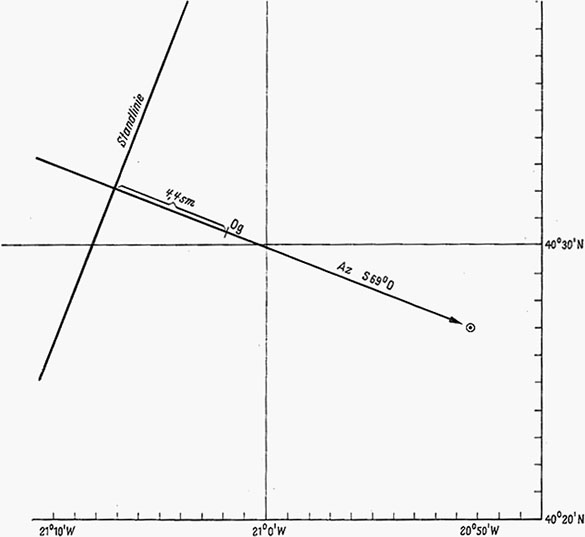
| Example of a position line calculation: On 4 May 1941 at 40° 30.5' N and 21° 2' W at GMT 10h 29m 52s. a sun altitude of 45° 34.1' was observed. | |||||||||||||||||||||||||||||||||||
|
|||||||||||||||||||||||||||||||||||
 |
|||||||||||||||||||||||||||||||||||
________________ |
|||||||||||||||||||||||||||||||||||
|
|
X Explanation. Pages I-IV of each month |
||
Explanation of the data |
||
Explanation. Pages I-IV of each month |
||
| The declination and equation of time of the true sun and the right ascension of the mean sun are given in two hour intervals. | ||
| For any other time (epoch) it is necessary to interpolate that which occurs in the first two values by estimating, in the third the hourly change of 10s. | ||
| Example: These three values are searched for on 3 October 1941 5h29m GMT | ||
| Page 128 yields: | ||
S 3° 48.5', –10m 48s and 12h 46m 7s. |
||
| The deviation of the true sun is needed to utilize solar observation to determine the local time, the geographical coordinates of the observing position and azimuth. | ||
| The equation of time is used for the transformation of apparent time into mean time and vice versa by the equations: | ||
| Apparent time plus equation of time = mean time | ||
| or mean time minus equation of time = apparent time | ||
| The right ascension of the mean sun is used for transformation of mean time in time angle of the first point of Aries from the lower meridian in the sense of the apparent daily motion of the celestial sphere and vice versa by the equations: | ||
♈τ = MOZ +⊙ α [MOZ = local mean solar time] |
||
| or MOZ = ♈τ – ⊙ α. [α = right ascension] | ||
| The radius of the sun is seen from Earth angle between the center and edge of the sun; it is needed to feed the edge observations to the center. | ||
| The radius of the sun is seen from Earth as the angle between the center and limb of the sun; it is necessary to correct the limb observations to the center. | ||
| On page IV bottom right you will find a correction of GMT valid for the respective month for the next four years in order to make use of pages I to IV of the 1941 Edition. | ||
| Example: These three values are searched for on 30 January 1942 16h 49m GMT | ||
| On page 5 lower right one finds the correction for the epoch 1942 to 1941 as -5.8h. | ||
| This yields as epoch 30 January 1941 16.8h – 5.8h = 30 January 1941 30 11.0h | ||
| With this page 5 yields the three values as | ||
S 17° 41.6', –13m 23s and 20h 37m 9s. |
||
|
|
Explanation. Pages V-VII of each month XI |
||
Page V of each month |
||
| The right ascension of the true sun is used for the conversion of real time in time angle of the first point of Aries from the lower meridian in terms of the apparent daily motion of the celestial sphere and vice versa by the equations: | ||
♈τ = WOZ + w⊙ α [WOZ = local apparent solar time] |
||
| or WOZ = ♈τ – w⊙ α [α = right ascension] | ||
| To determine the right ascension of the true sun more precisely, the equation of time is added to the right ascension of the mean sun from the tables for on pages I-IV each month - according to the definition given for this. | ||
| The deviation of the sun at true noon is mainly used to determine the meridian altitude of the sun at the geographic latitude. The change for 1° of longitude serves to convert here and for all values which can be taken for a given longitude | ||
| The mean local time of meridian passage of the moon at Greenwich is used for meridian- and adjacent meridian observations of the moon and to determine the rising and setting time of the moon. | ||
| It also serves as a basis for calculating the flood times. | ||
| For places in east (west) longitude meridian passage occurs earlier (later) than in Greenwich. Due to the daily retardation of about 50m, in each month at the time of the full moon (new moon) there is a day in which no passage through the upper (lower) Greenwich meridian occurs which is indicated with a dash. | ||
| At the bottom of the page, the Greenwich mean time of the phases of the moon or luminous figure are indicated. New moon, first quarter, full moon and last quarter occur when the position of the moon from the sun, calculated on the ecliptic is 0°, 90°, 180°, and 270°. | ||
Page VI to XII of each month |
||
| The right ascension and declination of the moon, as it appears from the center of the Earth, are given by the hour, namely the even hours in the first column, for the odd hour in the second column. To interpolate the change in a minute. | ||
|
|
XII Explanation. Pages XIII and XIV of each month |
|||||||||||||||||
| The radius of the moon is the angle viewed from the center of the earth between the center and the limb of the moon; it is needed to correct the limb observations to the Moon's center. | |||||||||||||||||
| The equatorial horizontal parallax of the moon, just called horizontal parallax is the angle at which the equatorial radius of the earth appears from the Moon's center. | |||||||||||||||||
| It is used to correct moon observations made from the surface to the center of the earth. | |||||||||||||||||
| Both values, radius and horizontal parallax, are given for two to two hours. Interpolation is done by estimation. | |||||||||||||||||
| In the days around New Moon all are carried to the moon related values are at larger intervals. The second column of the right ascension and declination then refer to 6h and 18h. | |||||||||||||||||
| Example: Sought is the right ascension, declination, radius and horizontal parallax of the moon for 1941 June 14 17h 22m 25s GMT (Page 80). | |||||||||||||||||
|
|||||||||||||||||
radius = 15.4' horizontal parallax = 56.5' |
|||||||||||||||||
Page VIII to XIV of each month |
|||||||||||||||||
| The right ascension and declination of the four bright planets Venus, Mars, Jupiter and Saturn as they appear from the center of the Earth, are given for 0h (midnight) GMT; the hourly changes serves to interpolate. | |||||||||||||||||
| The mean local time of the meridian passage in Greenwich can be taken every other position as approximate local mean time of passage through the upper meridian, and are then used to determine the favorable period for a latitude observation and the approximate calculation of the rise and set times. | |||||||||||||||||
| For more exact purposes you turn to the longitude and the difference between the two encompassing passage times. | |||||||||||||||||
| Example: Sought is the right ascension and declination of Jupiter for 5 September 1941 at the time of passage through the upper meridian at 56°W. | |||||||||||||||||
| Meridian passage takes place (Page 127) around 6h 19m mean local time = 5 September 10h 3m GMT. | |||||||||||||||||
|
|||||||||||||||||
|
|
Explanation. Pages 170-175 XIII |
||
| Horizontal parallax, specifically equatorial horizontal parallax is given at the foot of the pages for the middle of the month. | ||
Pages 170-171. Mean location of 80 stars for January 1. The list includes all stars down to the 3rd magnitude class and in star-poor regions some fainter. |
||
| The magnitude class is recognized in the Annals of Harvard College (Vol. 50), which is based on uniform photometric measurements. Under the assumption that the North Star is magnitude 2.12, and that the light intensities of the stars of two successive size classes are in a constant ratio (2.512), one gets the two brightest stars Canopus (–0.9) and Sirius (–1.6) to negative numbers. In this case, the number I is set as magnitude. | ||
| Pages 172-175. These pages contain the apparent location for the same 80 stars at three month intervals. | ||
| All stars brighter than 1.0 magnitude are recognized here as approximately magnitude 1, also for double stars, for which the magnitude of each star is given in the list of mean location, area recognized only by the total light intensity in the form of a magnitude class here. | ||
________________ |
||
|
|
XIV Explanation. Tables 1-3 |
||||||||||||||||||||||||||||||
Explanation of the Tables |
||||||||||||||||||||||||||||||
| Table 1. Pages 176-177. Ephemeris of Mercury for the period of its greatest apparent distance from the Sun | ||||||||||||||||||||||||||||||
| Right ascension and declination of the planet is given in the same manner as for the 4 bright planets | ||||||||||||||||||||||||||||||
| Table 2. Pages 178-183. Determination of latitude from the altitude of the North Star. | ||||||||||||||||||||||||||||||
| This table yields three adjustments that you must add algebraically to the true altitude of the North Star to obtain latitude. The table inputs for these three adjustments are: | ||||||||||||||||||||||||||||||
| 1. Time angle of the first point of Aries (♈τ) | ||||||||||||||||||||||||||||||
| 2. True altitude of the North Star and ♈τ | ||||||||||||||||||||||||||||||
| 3. Observation data and ♈τ | ||||||||||||||||||||||||||||||
| In the latitudes mainly visited by shipping by mere consideration of the first correction the latitude is obtained within an accuracy of a minute of arc. (See Annalen der Hydrographie etc. 1902 Page 576.) | ||||||||||||||||||||||||||||||
| Example: 1941 December 29 18h 35m 30s mean local time in 35° 3'W and 28° 0'N the true altitude of the North Star was found to be 29° 8' 30". The latitude of the observing position is calculated as follows. | ||||||||||||||||||||||||||||||
|
||||||||||||||||||||||||||||||
| Table 3. Page 184. Azimuth of the North Star. Contrary to previous types the table has been fashioned according to the proposal by Captain H. Lemke, so that their use only requires knowledge of the mean local time. The azimuth is specified by the method: from north clockwise from 0° to 360°. The column +φ = h yields the value that you must apply to the plotted latitude to obtain the approximate altitude of the North Star for setting on the sextant. | ||||||||||||||||||||||||||||||
________________ |
||||||||||||||||||||||||||||||
|
|
Solar and lunar eclipses XV |
|||||||||||||||||
Solar and lunar eclipses |
|||||||||||||||||
| In 1941 two solar eclipses and two lunar eclipses will occur. | |||||||||||||||||
| 1. Partial lunar eclipse on 13 March. The beginning of the eclipse will be visible in North America except in the extreme north-east, in the western part of South America, the Pacific, in Australia and in East Asia. The end is visible in the western part of North America, the Pacific, in Australia, in the East Asia and in the eastern part of the Indian Ocean. | |||||||||||||||||
|
|||||||||||||||||
| 2, Annular solar eclipse on 27 March. The eclipse will be visible in Zealand, in Polynesia, in the southern part of the Pacific, in Central America, in the Antilles and in South America with the exception of the eastern part. | |||||||||||||||||
|
|||||||||||||||||
| 3. Partial lunar eclipse on 5 September. The beginning of the eclipse will be visible in extreme northwestern North America, in the western half of the Pacific Ocean, In Australis, in the Indian Ocean, In Asia, in Eastern Europe and in Africa with the exception of the northwestern part. The end is visible in the western part of the Pacific Ocean, in Australia, in the Indian Ocean, in Asia, In Europe with the exception of the southwestern part and in Africa with the exception of the northwestern part. | |||||||||||||||||
|
|||||||||||||||||
| Total solar eclipse on 21 September. The eclipse will be visible in eastern Europe, in the Red Sea, in Asia on the Sunda Islands and on the Philippines, in New Guinea, in the northern part of Australia, in Japan, in the northwestern part of the Pacific Ocean and in extreme west of Alaska. | |||||||||||||||||
|
|||||||||||||||||
________________ |
|||||||||||||||||
|
|
XVI Calendar and Celebrations |
||||||||||||||||||||||||||||||||||||||||||||||||||||
Calendar and Celebrations 1941 |
||||||||||||||||||||||||||||||||||||||||||||||||||||
| The year 1941 equates to the year 6654 of the Julian period. | ||||||||||||||||||||||||||||||||||||||||||||||||||||
|
||||||||||||||||||||||||||||||||||||||||||||||||||||
________________ |
||||||||||||||||||||||||||||||||||||||||||||||||||||
|
||||||||||||||||||||||||||||||||||||||||||||||||||||
________________ |
||||||||||||||||||||||||||||||||||||||||||||||||||||
| Golden number, Sun circle and Roman number for the year J is compared sequentially to, the alignment of a 19 year lunar cycle, the dates of the 28 years of the solar cycle and the dates of the 15 years of the year Indiktion cycle J. | ||||||||||||||||||||||||||||||||||||||||||||||||||||
| The Julian epact gives the moon's age on 1 January Julian date, the Gregorian epact is the moon's age on 1 January Gregorian date. Designating sequentially, starting with 1 January, the day of the year with A, B, C, D, E, F, G, A, B, . . . , so the dominical letter is the one associated with the first Sunday in the year. Every leap year has two dominical letters, of which is the first Sunday in the period before 23 February, the other is the first Sunday after 24 February. | ||||||||||||||||||||||||||||||||||||||||||||||||||||
________________ |
||||||||||||||||||||||||||||||||||||||||||||||||||||
|
|